Accuracy Near, Far, Above or Under – How is FIG Working Week 2020 Contributing
The skills that engineering surveyors had to acquire in order to respond to the challenges of the construction world have made them capable, also, of fulfilling other challenges, several of which motivated by an awareness of the limitations of our planet. Engineering surveyors have learned that they need to push the equipment and techniques to its limits, while having recognized the necessity to integrate new techniques which can present more complete answers, without forgetting an important qualifier: accuracy. The instruments and methodologies have allowed for the surveying engineers to start working either very closely to the studied object, or, otherwise, from afar. In addition, there is new equipment able to provide aerial or subterranean information, especially to what regards underwater environments.
Furthermore, Commission 6 has established for the period of 2019-2022 three Working Groups (WG). The first one, 6.1 - Deformation Monitoring and Analysis, is a major contributor in the domain of safety of structures, an area of work only given due importance by the general public, when accidents occur. The second WG results from the dangers that landslides present to people and infrastructures, as well as from the importance of detecting/predicting their behaviour in space and time. Naturally, the name of this WG is Landslides Monitoring. The third WG is deeply related to a technique used for data collection, the (drone?) photography, when the camera is transported by unmanned aerial vehicles (UAV). The name of this WG is UAV for surveying. The gathering of both camera and UAV, along with developments in the software area, have rehabilitated the photogrammetry, including terrestrial (photography?), as a most valuable technique. It is indeed applied in several domains: cartography, monitoring, cadastre, engineering works construction, and environmental studies contain just a few of the many possible examples.
The highlights of Commission 6 in FIG Working Week 2020
The Working Week 2020, has the overall theme Smart Surveyors for Land and Water Management. In this major event for surveyours and other geospatial experts, FIG is pursuing one of its main purposes, namely the enhancement of skills and knowledge of these professionals. The ones interested in the engineering survey themes can, for this reason, find in the Working Week new information to further their expertise. But if up to some years ago the world of engineering surveyors was, as referred, strictly related to the domain of engineering, the technical sessions of the Working Week 2020 are good example of how the activity is expanding into new fields. This clearly demonstrates how our large and diverse group of professionals are aware of the limitations of our planet and how they can contribute to a more substantial field of knowledge.
The organizers of Working Week 2020 have established three main subthemes. It is in the first one - Smart Surveyors – that commission 6 has included its four technical sessions and two joint technical sessions with commission 5 - Positioning and Measurement. Nevertheless, the other subthemes - Integrated Land and Water Management and Ten years to go to achieve the Sustainable Development Goals – have attracted just as much attention from our experts.
The content of these sessions will below be presented in some detail. The structure of these sessions has a common vector. The first group of papers, more related to techniques and their application, become a good motivation to the second group, focusing on theoretical and technical questions, as well as attempting to present solutions or valuable proposals for future work.
TS01B: UAV & Photogrammetry: Techniques for Smart Surveyors
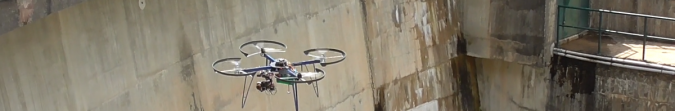
The session focuses on the latest tool for surveyors: the UAV. More commonly known as drones, some people also call them flying tripods, very sophisticated ones, that is. They are wonderful aerial platforms that have increased not only the amount of work conducted by geospatial professionals but have, likewise, opened the door to new intervention domains. At this point it is also important to mention that UAV technology is not the only reason behind this subject’s success. The re-born of photogrammetry proves to be another valuable tool. The newly developed computing techniques, having become user-friendly, and with software compatible to affordable computers, have proven important to the majority of the common producers of photogrammetric products. Of the six papers included in this session, three present examples of the use of photogrammetry: underwater, terrestrial and aerial. Among the other three papers, one tackles open source software, while the other two are related to technologies for an improvement of the results.
TS03B: Deformation Modelling for Smarter Surveying
We are living in a changing world. Some of these changes happen slowly, while others come about too fast, often in a highly unpredictable way. On the other hand, while some of these changes have little effect, and could, thus be neglected, others cause damage beyond imaging. Some of these changes can be detected and measured, providing important information of their evolution. The technical session includes three studies on deformation or other changes, in artificial or natural structures, while the fourth paper forwards a study related to deformation analysis.
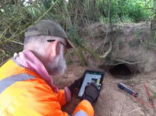
TS04B: Areal Measurement Techniques in Engineering Surveying (Laser Scanner & InSAR)
The session concerns two different techniques - laser scanner and satellite-based InSAr – while expounding their use in monitoring. Yet, it includes, also, answers to the challenge of automatic object detection and the ever-important issue of equipment calibration, applied to laser scanners. This session in particular assembles the most presentations arising from the construction world, given their relation to coastal areas (beaches or slopes near the sea).
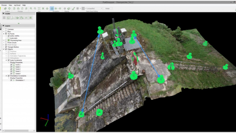
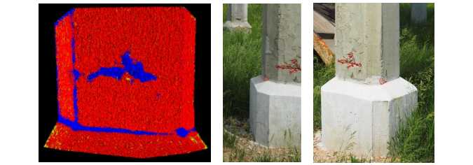
TS05B: Point Cloud-based Monitoring in Engineering Surveying
Point clouds is the subject that has attracted most papers among the many subjects related to C6. Sessions from other commissions have included some papers regarding this subject as well. Point clouds are challenging for the engineering surveyors that use laser scanners or digital cameras. These are valuable tools to describe the geometry of surfaces, to measure, and to evaluate changes. While it remains true these point clouds have brought about new obstacles, they nonetheless created new opportunities of work as well. Hence, this session is dedicated to spatio-temporal monitoring of artificial and natural objects with the aid of 3D point clouds acquired by means of multi-sensor-systems. It results from the cooperation between commission 6 and the former IAG working group 4.1.3 “3D point cloud based spatio-temporal monitoring”.
TS06G: Geodesy and Engineering
Created to be short and inspirational, this session was organized in accordance with commission 5. The session includes 12 papers, and it would have given the authors the possibility to present their contributions in an incisive way. Many are, content-wise, “out of the box” topics that alert to the many fields we, geospatial experts, can contribute to.
TS08B: Modern Technologies in Structural Monitoring
The objects studied or surveyed, referred in the papers of the session, are engineering works. This session in specific would appear quite traditional when compared to the other commission 6 technical sessions. This would be so, indeed, if it were not for an important detail: the access to information of the latest techniques, applied to a diversified scope of structures, ranging from the underwater port structures to the tallest buildings in the world.
Announcement upcoming events
As expected, in the wake of our present situation, the activities of commission 6 were affected. The 8th International Conference on Engineering Surveying INGEO2020, which would take place in Dubrovnik (Croatia) in April was postponed, with no determinate date yet. To get more information access the website http://ingeo-sig2020.hgd1952.hr/
Concerning SCEgeo – the 28th Conference "Surveying, Civil Engineering, Geoinformation in Sustainable development", with the UTP University of Science and Technology of Poland as its main organizer, it was decided to modify the conference formula. The conference will be carried out using interactive multimedia communication. To get more information access the website http://www.scegeo.utp.edu.pl/
Conclusion
The diversity and quality of the communications gathered at FIG Working Week 2020 prove, once again, the event’s importance for the community of professionals. The six technical sessions of commission 6, perhaps the most technical among all ten FIG commissions, are no exception and showcase the diversity of domains in which the professionals work, domains which generate many varied problems, yet which also present techniques that allow for an advance in quality, efficiency, and productivity. As it is known that the next FIG Working Week in 2021 will remain in the Netherlands, commission 6 challenges the engineering surveyors to participate and get in touch with the latest developments, as well as to present their own work.
Further readings:
FIG Working Week 2020 Proceedings
FIG Surveyors Reference Library
FIG Peer Review Journal
FIG Publications
FIG Commission 6 Sessions:
- TS01B: UAV & Photogrammetry: Techniques for Smart Surveyors
- TS03B: Deformation Modelling for Smarter Surveying
- TS04B: Areal Measurement Techniques in Engineering Surveying (Laser Scanner & InSAR)
- TS05B: Point Cloud-based Monitoring in Engineering Surveying
- TS06G: Geodesy and Engineering
- TS08B: Modern Technologies in Structural Monitoring
FIG Commission 6 website:

Value staying current with geomatics?
Stay on the map with our expertly curated newsletters.
We provide educational insights, industry updates, and inspiring stories to help you learn, grow, and reach your full potential in your field. Don't miss out - subscribe today and ensure you're always informed, educated, and inspired.
Choose your newsletter(s)