Today's three main trends in geospatial technology are bigger datasets, faster digital adoption and autonomous connected ecosystems, according to Josh Weiss, Chief Digital Officer at Hexagon’s Geosystems division.
If there is one thing I’ve learned during my last year and a half as Chief Digital Officer at Hexagon’s Geosystems division, technology is in constant evolution. From cutting my teeth in the steel industry to leading Hexagon’s Mining division, I’ve had a front-row seat to the continuous advancements in geospatial technology and its use in various industrial applications, such as vehicle safety systems and 3D laser scanning visualization.
While there is outstanding potential across our industry with new technologies – everything from self-learning instruments to connecting Internet of Things (IoT) ecosystems – the three main trends I will concentrate on here can be summed up as bigger datasets, faster digital adoption, and an ever-closer move to autonomous connected ecosystems.
Becoming bigger and better
In the now cornerstone book on the topic, “Big Data” by Kenneth Cukier and Viktor Mayer-Schönberger, there is a factoid that never ceases to amaze me. Each person on Earth now has 320 times more information than the whole of the Library of Alexandria in the third century, known then as the pinnacle of all human knowledge. Considering that the book was first published in 2013, that number has certainly exponentially increased.
This explosion of data, however, has also created a gap between production and usage. The human brain is not made to handle the amount of stimulation that is being directed at us daily. As datasets increasingly grow in volume and to avoid data overload, this data must become smarter. A shield between us and the data must be formed to protect from the overwhelming mass. How do we form that shield? Through technologies such as artificial intelligence (AI), edge computing and machine learning.
At Hexagon, we have shifted our business focus to capture, digitalize and unite data in what we call the Smart Digital Reality. In this reality, data is digitally accessible, providing seamless access to physical world information in a digital world; infinitely connected, drawing and acting on data from multiple sources simultaneously; and autonomously intelligent, leveraging data to make unaided decisions and becoming smarter over time. This is how we put data to work to do its greatest good.
Digitalizing faster and more efficiently
We’ve been thrown many curveballs in 2020, notably a global pandemic that has sent most businesses into remote working and online networking. We have all had to embrace new ways to come together, stay connected, and work toward revamped goals in this 'new normal’. Through, and perhaps due to, these difficulties, we’re witnessing the faster adoption of digitalization strategies to adapt business models and overcome these newfound challenges.
We have seen a spectrum of preparation from companies across the board when the situation forced a new era of socially distanced operations. Some were further along their digitalization journeys and, therefore, better equipped to make the quick changes needed to continue business. Those who were not are quickly adjusting based on lessons learned.
Be it industry-changing inventions, such as the cotton gin kicking off the Industrial Revolution, or a worldwide crisis, as we are currently experiencing, the need for rapid innovation to adapt to these changes always brings evolution. As digitalization continues to drive business and society forward, those who are flexible and adopting these strategies now or even before will be the clear winners. Those who continue to resist and are waiting for “things to get back to normal” only make it harder for themselves in the inevitable outcome.
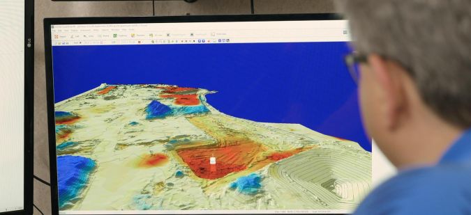
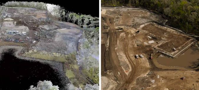
In the geospatial industry, this outcome includes increasing and more rapid use of reality capture solutions to create digital twins of sites to continue work. The exact replica of a mine, which is often hundreds if not thousands of miles away in an extremely remote area and with many inaccessible parts such as vertical mine shafts, allows operators to seamlessly work without delay. In construction, we are seeing crews working more with laser scanning point clouds to perform as-built checks, all from a distance when physical access to a site is not possible. Cloud-accessible platforms where all project information is shared among stakeholders for a 360-degree understanding, such as Leica ConX, is also playing a part in the digitalization journey into this new era of business.
The next stop on the journey is automation.
Automating more and further
When these vast amounts of data are digitalized and can make unaided decisions free from human interaction, we have then reached automation. This state of self-sufficient technology through algorithms learns from mistakes, becomes smarter over time, and rounds out the Smart Digital Reality. Autonomy is data performing at its best, most advanced state.
Autonomous solutions go beyond just self-driving automobiles. The AI integral to this technology will enable machines to understand not only their own systems but external situations around them. With the optimization of vehicles and fleets, these automobiles will be able to regulate themselves and automatically know when to speed up or slow down, resulting in smooth flows of traffic, significantly less congestion and jams, and overall sounder travel capabilities. As algorithms and advanced analytics continue to consume data and educate themselves, we will see safer cities, cleaner energy sources, smarter buildings, and a more sustainable future.
Automating in geospatial technologies comes in various forms. For example, our HxGN Content Program, the largest library of high-accuracy airborne data, offers aerial imagery collected on a regular schedule for repeatable information. These normalized datasets are easily consumed by algorithms that feed and train machine learning and AI, making it possible for these technologies to perform automatic updates, like change detection, faster and at lower costs.
The old saying ‘the only constant in life is change’ is nowhere truer than technology, especially geospatial technology. As I continue my front-row-seat view of these advancements, I will never lose the sense of awe of how we as individuals in this field can make an impact on empowering an autonomous and sustainable future.