UNAM selects RIEGL sensor as its first aerial Lidar system
The University of Nacional Autónoma de México (UNAM) has recently procured a RIEGL VQ-1560 II-S airborne system through its Institute of Geography. It has been added to the R&D project...

The University of Nacional Autónoma de México (UNAM) has recently procured a RIEGL VQ-1560 II-S airborne system through its Institute of Geography. It has been added to the R&D project...

Dedicated to the world’s tomorrow, Trimble is a technology company delivering solutions that enable our customers to work in new ways to measure, build, grow and move goods for a...
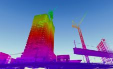
When it comes to 3D modelling for construction, what are the advantages and disadvantages of photogrammetry versus Lidar in terms of accuracy, complexity and cost? Breaking away from laser measurement...

Join Noah Eckhous from NavVis and Mike Walle from Denn Engineers in downtown Culver City to explore how SLAM-based data capture technology transforms topographic survey workflows. In this video, we...
The ancient imperial city of Fez, Morocco, is an important tourist attraction and has been listed as a UNESCO World Heritage Site since 1981. The layout of the city is...
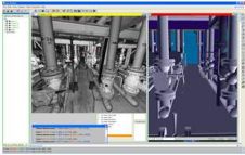
A new product in the AVEVA Plant portfolio is AVEVA Laser Modeller, a 3D laser scanning software solution that can reduce by up to 50% the time for intelligent 3D...
A new solution from GTA (Germany) and Procedural offers more 3D detail in modelling of large databases of real-world building data. Special focus is set to add depth to the...
Three-dimensional documentation of heritage buildings is important for conservation, restoration and education. When it comes to complex architectural structures such as castles, no single modelling technique is capable of yielding...
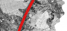
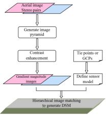
Thanks to rapid improvements in aerial laser scanning systems, they offer great potential in road surveying compared with traditional photogrammetry-based methods. Using the high-density 3D point clouds resulting from aerial...

Maxar Intelligence has been awarded a contract to supply the National Geospatial-Intelligence Agency (NGA) with a Precision3D Data Suite bundle. This comprehensive package covers an extensive area of 160,000 square...
This site uses cookies. By continuing to use this website, you agree to our Cookies Policy. Agree