GIM - Issue 2-2024
Presenting the latest developments in aerial mapping, products and services. Intriguing real-life projects provide insights into advanced aerial photogrammetry and Lidar in practice. Moreover, this edition looks at how AI...

Presenting the latest developments in aerial mapping, products and services. Intriguing real-life projects provide insights into advanced aerial photogrammetry and Lidar in practice. Moreover, this edition looks at how AI...

Fujitsu has presented a pioneering technology that harnesses Lidar and AI to capture high-resolution 3D data of organisms, coral reefs and man-made structures such as offshore wind turbines using autonomous...

3D TARGET was founded as a trading company and official distributor of non-destructive measuring instruments. In 2016, we created an internal R&D division dedicated to system integration and designed a...

3D visualization is at the heart of many geospatial data applications. Progress in 3D visualization has drastically reduced barriers to entry for new products based on large datasets, thanks to...
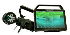
Exyn Technologies has unveiled Exyn Nexys, an innovative modular 3D mapping solution. Designed for professionals in the mining, construction, AEC and geospatial industries, Nexys aims to set a new standard...

Looq AI has announced the launch of its groundbreaking AI-enabled digital twin technology, the Looq platform. Positioned as a one-stop solution, it allows surveyors, engineers, contractors and asset owners to...
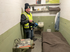
The rugged 22.5-acre site of the notorious US island prison Alcatraz has been digitally captured in a world-leading project involving multiple mapping technologies. With the team camped in the jail’s infamous cells for three weeks during the cold San Francisco winter, this historically, biologically and architecturally important location was recorded in unprecedented 3D detail. We discussed the project with project head Pete Kelsey and team member Dr Jeremy Sofonia. The rugged 22.5-acre site of the notorious US island prison Alcatraz has been digitally captured in a world-leading project involving multiple mapping technologies. With the team camped in the jail’s infamous cells...

NavVis recently unveiled a substantial enhancement in global 3D spatial technology access and performance. By launching new cloud regions in the Americas and Asia-Pacific (APAC), the company aims to elevate...

The Earth observation industry seems to be on a slow burn – but why? Brace yourself for a ‘rollercoaster ride’ through Earth observation as this article unravels the mysteries behind...

The Faroese Environment Agency, responsible for national mapping activities including land mapping and hydrographic surveying, has recently joined EuroGeographics, the representative body for European national mapping, cadastral and land registration...
This site uses cookies. By continuing to use this website, you agree to our Cookies Policy. Agree