UNIGIS UK

About ESRI (UK) Geographic information is at the heart of every organisation. It exists in almost every business system as customer addresses, property assets, operational areas, administrative boundaries, road and...

Juan Partida is CFO of the government of Jalisco, having been a public servant for the last 15 years. From the outset, his involvements have included modernizing and designing cadastral...
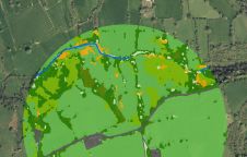
The UK’s Peak District National Park Authority is pioneering the use of artificial intelligence (AI) to automate the production of highly detailed land cover maps, in a project in partnership...

Inertial Labs has unveiled its latest innovation: high-precision three-axis accelerometers (TAA). These compact, self-contained devices mark a significant leap forward in navigation-grade accelerometers, promising unmatched precision in measuring linear accelerations....
COMCARE Emergency Response Alliance, the Open Geospatial Consortium, Inc. (OGC), the National Emergency Number Association (NENA) and the National Association of State Fire Marshals (NASFM) have jointly announced they will...
ACSM has appointed Tom Berkland, LS-PE, as the chair of the ACSM Communications Committee. Tom Berkland is Principal Engineer of City of Sioux Falls Public Works/ Engineering and a NSPS/GLIS...
Intergraph Corporation (AL, USA) has announced its participation in a demonstration of interoperable emergency communications. On 29 March 2005, more than 80 state, local and federal organisations and more than...
This site uses cookies. By continuing to use this website, you agree to our Cookies Policy. Agree