GEO Business Expands for 2018
GEO Business, the UK’s largest geospatial exhibition and conference, has grown year on year since its inception. In fact, the 2018 show looks set to be the most successful show...

GEO Business, the UK’s largest geospatial exhibition and conference, has grown year on year since its inception. In fact, the 2018 show looks set to be the most successful show...
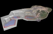
At Geo Week 2024 in Denver, Maptek unveiled its latest innovation: Maptek GeoSpatial Manager. This groundbreaking solution simplifies and streamlines workflows, revolutionizing how mining and civil engineering projects manage data...
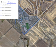
Trimble has unveiled the integration of the Trimble Applanix POSPac Cloud post-processed kinematic (PPK) GNSS positioning service, featuring CenterPoint RTX, with the UAV-based mapping and data collection capabilities of DroneDeploy’s reality...

Wingtra has unveiled its innovative Lidar-drone solution. The new Lidar payload is designed to seamlessly integrate the efficiency, ease of operation, and high accuracy of the WingtraOne GEN II drones...

In a new strategic partnership, Inertial Labs' RESEPI Payload Lidar technology will be integrated into E38's advanced E455 drone platform. This collaboration marks a significant milestone in the utilization of...

The last session of the conference Day One included a presentation on cyber security. Like health and safety, much of this topic is obvious - when you think about it....

The countdown is on for GEO Business 2023, a top trade event that brings together experts and professionals in the geospatial field. Co-located with the Digital Construction Week, the event...

Linda Foster oversees Esri’s worldwide strategic vision for land administration and surveying. With 20 years of experience working in the land and resource industry, she is a registered professional land...

There are indications that today’s technological advances are putting a fully operational multipurpose cadastre within reach, following decades of a global vision and small-scale progress towards a comprehensive map-centric land...
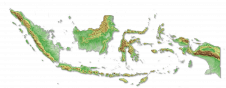
Intermap has won a US$20 million contract to map the Indonesian island of Sulawesi this year. The contract is the first phase of the Indonesian national topographic basemap programme to...
This site uses cookies. By continuing to use this website, you agree to our Cookies Policy. Agree