Stereo-matching Techniques
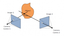
Automation in photogrammetry is largely made possible by stereo-matching techniques that enable (semi-)automatic aero-triangulation and creation of digital elevation models. Matching: I know what it is, I know what it...
Automation in photogrammetry is largely made possible by stereo-matching techniques that enable (semi-)automatic aero-triangulation and creation of digital elevation models. Matching: I know what it is, I know what it...

Over the past 20 years, various initiatives have been launched reflecting the importance of cadastral data for land management and spatial development. But how have these initiatives enhanced the possibility...

The organizers of Geo Week have announced an impressive list of more than 150 supporting partners that are backing the 2024 event. Geo Week is a leading conference and trade...

Jonathan Arthur Quaye-Ballard is a professor and head of the Department of Geomatic Engineering at KNUST, where he has worked for the past 20 years. He also holds a BSc...

Planet was founded with the mission to image the Earth every day and make change visible, accessible, and actionable. Over the past decade with our customers, Planet has revolutionized the...
Point clouds are increasingly a prime data source for 3D information. For many years, Lidar systems have been the main way to create point clouds. More recently, advances in the field...
GEO21_network-scaled

GEO Business will put the spotlight on geospatial innovation for two days long, from 17-18 May. At ExCeL London, around 3,500 geospatial professionals will come together to discover and debate...
This site uses cookies. By continuing to use this website, you agree to our Cookies Policy. Agree
