Found 8553 results
Sort by

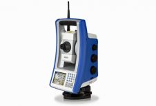
Portfolio of Optical Survey Solutions

Spectra Precision has introduced new additions to its Spectra Precision Focus line of optical survey solutions. With the new additions, survey and construction professionals have more positioning instrument choices to...

Read more

Geospatial Goes Global

This year’s annual conference of the American Society for Photogrammetry and Remote Sensing (ASPRS) took place from 7th to 11th March, with the theme ‘Geospatial Goes Global: From Your Neighbourhood...

Read more

Benefits of GIS in Urban Planning

Traditional methods of information management are hard to use in the planning process of problematic urban areas such as squatter settlements. GIS provides the capability for dynamic query and analysis,...

Read more

GIS for Urban Conservation

GIS is a very useful tool in the planning of urban conservation. GIS includes integration of vector and raster data, geographical referencing, correction and spatial adjustment. GIS analysis tools and...

Read more

Helpless Caesars of Technology

Disasters are of all ages. When they strike, more often than not they strike suddenly and ruthlessly. The damage disasters cause fills us with deep awe for the unimaginable forces...

Read more

Integrated Coastal Zone Management

An integrated approach towards coastal zone management requires relevant, credible and reliable (geo-)data. However, the legends of geo-information covering coastal zones vary so much between the various European countries that...

Read more

The Stresses and Strains of Legal Liason

Approximately 21,000,000 properties exist in England and Wales, ranging from small houses with tiny gardens to large rural estates. Boundary disputes are relatively rare and involve an average of 100mm...

Read more