Why hasn’t the Earth observation industry taken off?
The Earth observation industry seems to be on a slow burn – but why? Brace yourself for a ‘rollercoaster ride’ through Earth observation as this article unravels the mysteries behind...

The Earth observation industry seems to be on a slow burn – but why? Brace yourself for a ‘rollercoaster ride’ through Earth observation as this article unravels the mysteries behind...

Despite some uncertainty, there is renewed interest in drones, and remote sensing technologies are being embraced by smaller survey companies. Read these and other findings from our annual industry survey!...
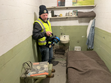
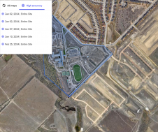
The rugged 22.5-acre site of the notorious US island prison Alcatraz has been digitally captured in a world-leading project involving multiple mapping technologies. With the team camped in the jail’s infamous cells for three weeks during the cold San Francisco winter, this historically, biologically and architecturally important location was recorded in unprecedented 3D detail. We discussed the project with project head Pete Kelsey and team member Dr Jeremy Sofonia. The rugged 22.5-acre site of the notorious US island prison Alcatraz has been digitally captured in a world-leading project involving multiple mapping technologies. With the team camped in the jail’s infamous cells...

3D visualization is at the heart of many geospatial data applications. Progress in 3D visualization has drastically reduced barriers to entry for new products based on large datasets, thanks to...

Visitor registration is now open for GEO Business, the UK's largest geospatial event. The free-to-attend expo, tailored for geospatial professionals seeking to harness the potential of location intelligence, will return...
Trimble has unveiled the integration of the Trimble Applanix POSPac Cloud post-processed kinematic (PPK) GNSS positioning service, featuring CenterPoint RTX, with the UAV-based mapping and data collection capabilities of DroneDeploy’s reality...
MicaSense has released RedEdge-M, the evolution of its rugged, built-to-last, professional multispectral sensor, RedEdge. Easily integrated into a wide variety of drones, RedEdge-M enables agricultural enterprises, growers and researchers to...
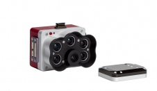
AgEagle Aerial Systems has launched MicaSense’s latest innovation in leading-edge drone sensor technology, the RedEdge-P. Offering three times the capture speed and twice the spatial resolution of the RedEdge-MX, the all-new RedEdge-P...
senseFly has introduced the eBee X with the MicaSense RedEdge-MX camera, a dual solution for accurate and efficient crop analysis. By combining the eBee X with the MicaSense RedEdge-MX, it enables farming,...
MicaSense Atlas is now integrated with Pix4D desktop software. This new partnership is designed to offer MicaSense customers the power of desktop processing, as well as the flexibility of MicaSense...
This site uses cookies. By continuing to use this website, you agree to our Cookies Policy. Agree