UML in Use Case Modelling
Modelling is a well-proven and widely accepted engineering technique for controlling complex reality. Unified Modeling Language (UML) is a general-purpose aid for graphical modelling. The author presents a use case...
Modelling is a well-proven and widely accepted engineering technique for controlling complex reality. Unified Modeling Language (UML) is a general-purpose aid for graphical modelling. The author presents a use case...

Luis Rodrigoandrés Morales holds an MSc in Geoinformation Science and Earth Observation with a specialized focus on urban planning and management from the University of Twente, the Netherlands. Currently, he...
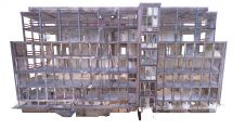
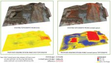
Terrestrial laser scanning is becoming increasingly important as the software and technology-related developments in many spheres of society mean that ever-higher standards are being set in terms of quality and...
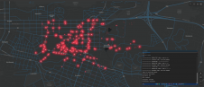
How can city digital twins support the attainment of SDG11? They can be used to manage infrastructures (e.g. roads, transportation and public services, smarter energy grids and water networks), support...
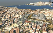
The Turkish city of Istanbul is developing a 3D city model mainly aimed at urban planning. The data sources used so far include airborne Lidar, aerial images and 2D maps...
The Turkish city of Istanbul is developing a 3D city model mainly aimed at urban planning. The data sources used so far include airborne Lidar, aerial images and 2D maps...
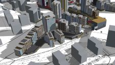
As 3D models are becoming common geospatial data assets for cities around the world, a recent study reviewed major 3D city modelling activities in Finland. 3D city models can be...

The University of Melbourne has developed an advanced modelling tool that can predict boundaries of landslides up to a fortnight before they occur. Researchers at the School of Mathematics and Statistics...

Mobile scanning can be an equally accurate yet more cost-effective solution than traditional terrestrial laser scanning done with tripods. To succeed, however, mobile scanners not only require a suitable combination...
Is the 3D model becoming the only deliverable? For construction, is photogrammetry a better option than LiDAR? How long before modelling software can calculate costs? When should you start mentioning...
This site uses cookies. By continuing to use this website, you agree to our Cookies Policy. Agree