Maptek Demonstrates Resource Modelling Technology at PDAC
With the investment stream opening up, visitors to this year’s PDAC in Toronto, Canada, will be keen to explore resource estimation and project evaluation tools that can add value to...
With the investment stream opening up, visitors to this year’s PDAC in Toronto, Canada, will be keen to explore resource estimation and project evaluation tools that can add value to...

Bentley Systems held its latest annual Year in Infrastructure Conference in London, UK. The event proved to be an excellent opportunity to take a look behind the scenes at Bentley, a...

The rapid developments in the fields of photogrammetry, laser scanning, computer vision and robotics provide highly accurate 3D data. 3D models that can be created from such types of data...

GW reports on last November’s RICS fascinating lecture by Andrew D. Thompson on how geomatics measurement techniques are being used in rights to light cases. Ever since man first began...

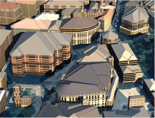
Accurate digital representations of cities are game changers in urban development. By enabling virtual modelling and smart simulations, they allow decision-makers to explore, test and assess the measures taken. Hosted...

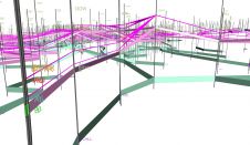
The second British Information Modelling (BIM) event proved a success with 100 delegates heading to the Arup’s central London headquarters during the last week of October. A fitting opening event...
OS Model Builder is a recently launched visualisation tool that can support projects, including Level 2 BIM activities, and was developed to save the construction industry and its clients’ time and money when...

In a recent project to obtain detailed and accurate orthoimages and 3D models to support technical staff in maintaining Prague Castle in the Czech Republic, the site was captured by...

European Association of Aerial Surveying Industries Planning, disaster management, and safety challenges inherent in complex urban environments call for innovative solutions. Researchers around the world are progressing the field, drawing upon cutting-edge work using approaches such...

The Open Geospatial Consortium will join EUROSDR, AGILE, JRC and ELF in presenting an important technical workshop focused on the geospatial elements of data models. The workshop will be held...
This site uses cookies. By continuing to use this website, you agree to our Cookies Policy. Agree