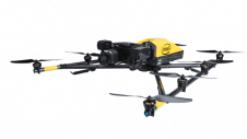
Found 6728 results
Sort by

Pix4D and Parrot Present New UAV Solution

UAV manufacturer Parrot and mapping software developer Pix4D recently presented their new drone solution for 3D modelling at the MIPIM conference in Cannes, France. Pix4D’s flight planning mobile app can...

Read more

Pix4D Unveils New Precision Agriculture Solutions

Pix4D has launched Pix4Dmapper Ag: photogrammetric software that converts multispectral images into agriculture-specific maps for better crop management and analysis. The software has been released in conjunction with Sequoia: a multispectral sensor...

Read more