Cartomorphosis: an evolution that starts with cadastre
Over the past 15 years, geospatial information has enabled the transformation of towns, cities and a whole state in Mexico. The customer and data provider teamed up to create up-to-date...
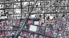
Over the past 15 years, geospatial information has enabled the transformation of towns, cities and a whole state in Mexico. The customer and data provider teamed up to create up-to-date...
Blue Marble Geographic’s flagship software, Global Mapper Pro, is an all-in-one GIS package for analysing and processing vector, terrain, image and point cloud data. Compatible with over 380 different file...
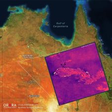
UP42 and OroraTech have signed a partnership agreement to grant easy and fast access to global high-resolution thermal-infrared imagery. UP42 is a geospatial developer platform and marketplace, and OroraTech is...
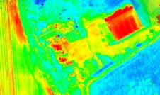
Topodrone has recently unveiled a cutting-edge drone thermal mapping solution: the Topodrone PT61 camera, designed to conduct detailed surveys and generate thermal orthomosaic maps, facilitating the creation of accurate 3D...

The revolutionary use of active GNSS control points and cutting-edge geomatics equipment is setting new standards for accuracy in the construction of high-rise architecture, as demonstrated by this skyscraper project...
CGGVeritas has inaugurated a new open Processing & Imaging center in Muscat, Oman at a ceremony attended by clients and a delegation from the Omani Ministry of Oil & Gas....
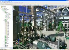
Leica Geosystems announces the exclusive distribution of RealityLINx Model 5.4 - powered by Leica point cloud Engine (pcE) technology. RealityLINx Model 5.4 speeds and simplifies the processing of as-built laser...
ITT and ESRI have taken on a strategic partnership to integrate their respective software technologies. This integration delivers advanced, image processing and analysis capabilities to the ArcGIS platform and expands...
The Norwegian company Terratec has introduced software capable of accurate positioning based on post-processing of GPS-observations, without the use of reference stations or DGPS services. Typical accuracy for kinematic applications...

Both vertical and oblique aerial images have their own advantages, making them valuable in different reality mapping applications. So how can you choose between the two? This comparison will help...
This site uses cookies. By continuing to use this website, you agree to our Cookies Policy. Agree