The Production of Mapping and the Mapping of Production
Philippe de Maeyer (Belgium), chair of Commission on Map Production and GeoBusiness. It must be recognised that in contemporary cartography, 99% of the maps which are conceived are...

Philippe de Maeyer (Belgium), chair of Commission on Map Production and GeoBusiness. It must be recognised that in contemporary cartography, 99% of the maps which are conceived are...
GeoEye has completed an expansion, nearly doubling the production space, of its St. Louis production facility. A ceremony to mark the opening of the new space took place on 27th...
Innovative methodologies based on artificial intelligence (AI) are lowering the barriers and democratizing the use of 3D digital twins in the geospatial industry. Digital twins are revolutionizing the geospatial industry,...
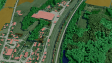
The US Geological Survey (USGS) and Dewberry have jointly released a new topobathymetric Lidar dataset for the Potomac River, extending from the Potomac Highlands in West Virginia to the Chesapeake...
GeoEye has received two new awards worth more than USD25 million. These awards will increase the backlog for the company's production services line of business. The first is a Delivery...
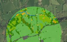
The UK’s Peak District National Park Authority is pioneering the use of artificial intelligence (AI) to automate the production of highly detailed land cover maps, in a project in partnership...

Both vertical and oblique aerial images have their own advantages, making them valuable in different reality mapping applications. So how can you choose between the two? This comparison will help...
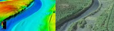
Hydrographic Offices (HOs) have realized that bathymetric data is not sufficiently represented in Electronic Navigational Charts (ENCs). A few aspects of this topic have already been touched upon in the...
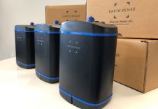
EarthSense has announced that its Zephyr air quality monitor, an industry-first in small sensor technology with replaceable cartridge system, will go into mass production. The Zephyr is a multi-sensor platform...

In a groundbreaking collaboration, Genesys International and Survey of India (SOI) have formed a strategic alliance to create digital twins of major cities and towns. This partnership is aimed at...
This site uses cookies. By continuing to use this website, you agree to our Cookies Policy. Agree