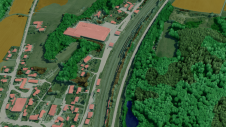
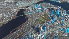
3D geospatial visualization
3D visualization is at the heart of many geospatial data applications. Progress in 3D visualization has drastically reduced barriers to entry for new products based on large datasets, thanks to...

3D visualization is at the heart of many geospatial data applications. Progress in 3D visualization has drastically reduced barriers to entry for new products based on large datasets, thanks to...
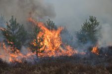
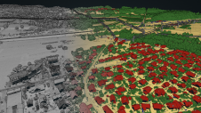
The number of wildfires has increased dramatically in recent years due to diminishing forest health caused by the drastically changing climate across the world. Longer dry-weather periods and pressure from a variety of pests and diseases, e.g. bark beetles, are affecting the large forest areas in Northern Europe. In addition to financial losses, these impacts are resulting in lower carbon accumulation and vast ecological changes. The number of wildfires has increased dramatically in recent years due to diminishing forest health caused by the drastically changing climate across the world. Longer dry-weather periods and pressure from...
Innovative methodologies based on artificial intelligence (AI) are lowering the barriers and democratizing the use of 3D digital twins in the geospatial industry. Digital twins are revolutionizing the geospatial industry,...
Both vertical and oblique aerial images have their own advantages, making them valuable in different reality mapping applications. So how can you choose between the two? This comparison will help...
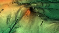
Remote sensing surveys in Antarctica based on unmanned aerial vehicles (UAVs or ‘drones’) have become a very important approach for a wide range of studies. Mapping free-from-ice-and-snow terrain and monitoring...
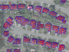
The creation of an accurately classified point cloud usually requires tremendous input from manual annotation. At Flai, we believe that all those repetitive procedures can be greatly reduced by using...
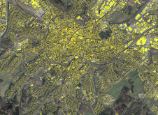
Global climate change and, in some areas, the lack of a cheap and reliable energy supply are contributing to the expansion of photovoltaics, both regionally and worldwide. In addition to...
MariaDB has acquired CubeWerx, a leader in geospatial solutions, for an undisclosed amount. With this acquisition, MariaDB adds cloud-native, scalable geospatial capabilities that the company plans to offer through its...

Morteza Esfandiari, MSc, is a geospatial technician with McElhanney Ltd. Morteza received his MSc in Geodesy and Geomatics Engineering from the University of New Brunswick in 2021. His research interests...
How can artificial intelligence and deep learning lead to a robust process for 3D city modelling? And what are some of the challenges? Automated classification and object detection in Lidar...
This site uses cookies. By continuing to use this website, you agree to our Cookies Policy. Agree