Lidar in surveying & mapping
Lidar, short for Light Detection and Ranging surveying, represents a sophisticated measuring system leveraging the power of light. Widely recognized for its versatility, Lidar is extensively applied in diverse fields...
Lidar, short for Light Detection and Ranging surveying, represents a sophisticated measuring system leveraging the power of light. Widely recognized for its versatility, Lidar is extensively applied in diverse fields...

Mosaic has partnered with Movella aimed at redefining precision and efficiency in mapping and 3D reconstruction projects. Mosaic is specialized in mobile mapping camera systems, while Movella is a renowned...
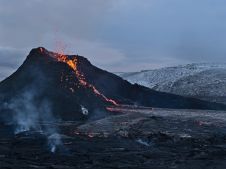
The Icelandic authorities have commissioned Acecore to map the extent and aftermath of the Eldvörp-Svartsengi volcanic system eruption using its high-end drone solutions. Grindavík, a fishing village on the Reykjanes...
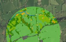
The UK’s Peak District National Park Authority is pioneering the use of artificial intelligence (AI) to automate the production of highly detailed land cover maps, in a project in partnership...
Trimble has unveiled the integration of the Trimble Applanix POSPac Cloud post-processed kinematic (PPK) GNSS positioning service, featuring CenterPoint RTX, with the UAV-based mapping and data collection capabilities of DroneDeploy’s reality...

3D TARGET was founded as a trading company and official distributor of non-destructive measuring instruments. In 2016, we created an internal R&D division dedicated to system integration and designed a...

In a high-flying endeavour spanning over six decades, the UK’s National Grid's fleet of advanced helicopters have been diligently patrolling pylons and power lines, ensuring the health and reliability of...

Recently unveiled by Vexcel Imaging, the groundbreaking UltraCam Dragon 4.1 represents one of the market's most advanced, progressively designed and seamlessly integrated hybrid aerial mapping systems. Tailored for high-resolution mapping...

3D visualization is at the heart of many geospatial data applications. Progress in 3D visualization has drastically reduced barriers to entry for new products based on large datasets, thanks to...
Leica Geosystems, part of Hexagon, has launched the Leica TerrainMapper-3 airborne Lidar sensor, featuring new scan pattern configurability to support the widest variety of applications and requirements in a single...
This site uses cookies. By continuing to use this website, you agree to our Cookies Policy. Agree