Planet
Planet was founded with the mission to image the Earth every day and make change visible, accessible, and actionable. Over the past decade with our customers, Planet has revolutionized the...

Planet was founded with the mission to image the Earth every day and make change visible, accessible, and actionable. Over the past decade with our customers, Planet has revolutionized the...

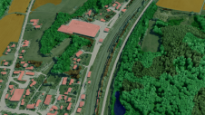
Hexagon's Safety, Infrastructure & Geospatial division together with Ness Czech will provide the Czech Railway Administration with a Digital Technical Railway Map (DTRM). This railway-specific GIS solution will give the...
Innovative methodologies based on artificial intelligence (AI) are lowering the barriers and democratizing the use of 3D digital twins in the geospatial industry. Digital twins are revolutionizing the geospatial industry,...

The National Spatial Data Infrastructure (NSDI) for the Kingdom of Bahrain was officially implemented in February 2005 by the GIS Directorate of the Central Informatics Organisation (CIO), Kingdom...

The geoportal software g.on aimPort will be represented at CeBIT 2011 in Hanover, to be held from 1st to 5th March 2011. Potential clients are mostly operators of industrial plants,...

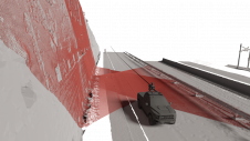
SimActive has announced the use of its Correlator3D product by Survtech Solutions for use in energy infrastructure mapping and monitoring. Using aerial imagery to colourize Lidar point clouds, a visual...
Bentley Systems has launched the Bentley Infrastructure Ambassadors Council. The newly appointed ambassadors will engage the global communities of practitioners, constituents, and organisations interested in the challenges of and opportunities...
Intergraph is expanding its proven utilities infrastructure management solutions with new, open standards-based spatial data infrastructure (SDI) capabilities to foster greater interoperability. Intergraph SDI capabilities enable secure, fast and seamless...
Exploring the complete potential of mobile laser scanning raises the question of whether the obtained results are sufficiently accurate for deformation monitoring. This article focuses on the geometric quality of...
Autodesk's new Infrastructure Modelling software products facilitates users in utilities, telecommunications organisations and government agencies improve the design and management of their infrastructure. Autodesk's portfolio of products - including AutoCAD...
This site uses cookies. By continuing to use this website, you agree to our Cookies Policy. Agree