Airborne Laser Scanning

RIEGL has announced the launch of two innovative topobathymetric scanners. These advancements mark a shift towards enhanced efficiency and precision in data collection across land and water interfaces. The RIEGL...
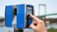
FARO Technologies, headquartered in Lake Mary, USA, is specialised in 3D measurement, imaging and realisation technology. The company develops and markets computer-aided measurement and imaging devices and software. The technology...
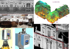
Terrestrial laser scanners are contact-free measuring devices which can collect dense point-clouds of objects. After processing each point is assigned with X, Y, Z coordinates; colour and reflectance value. The...
The latest version of Pointools Edit utilises the full power of 64-bit for faster editing and processing of point cloud data, the millions of 3D measurements collected by laser scanning...

RIEGL Laser Measurement Systems' V-Line laser scanner generation was a main feature in the overview of the company's laser scanner product range at Intergeo. The Austrian company was showing terrestrial,...
Z+F UK develop their own brand of laser scanning software called 'Light Form Modeller' or LFM. LFM is known for its array of CAD interfaces that allow users to seamlessly...
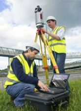
Combining Terrestrial Laser Scanning, Position and Orientation Systems and GPS receivers into a mobile mapping system enables effective mapping of large and complex terrain. The authors tested a mobile mapping...
Terrestrial 3D laser scanning will become the future standard tool for high-resolution 3D documentation of archaeological excavations, but its capabilities are still underestimated by professional archaeologists and providers of scanners...
This site uses cookies. By continuing to use this website, you agree to our Cookies Policy. Agree