GIM - Issue 2-2024
Presenting the latest developments in aerial mapping, products and services. Intriguing real-life projects provide insights into advanced aerial photogrammetry and Lidar in practice. Moreover, this edition looks at how AI...
Presenting the latest developments in aerial mapping, products and services. Intriguing real-life projects provide insights into advanced aerial photogrammetry and Lidar in practice. Moreover, this edition looks at how AI...

GEO Business, the UK’s premier geospatial event, is celebrating its tenth anniversary when it returns to ExCeL London on 5 and 6 June 2024. This edition promises to be the...

London Gatwick has created a new geospatial platform using Esri’s ArcGIS to support multiple operational areas at the airport, including engineering and environmental services. The system is already making engineering...

Fujitsu has presented a pioneering technology that harnesses Lidar and AI to capture high-resolution 3D data of organisms, coral reefs and man-made structures such as offshore wind turbines using autonomous...
Klau Geomatics has introduced the Brumby RTK Lidar system, an innovative mobile mapping solution equipped with powerful Edge Compute capabilities, enabling the generation of highly precise georeferenced point clouds in...

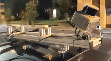
Trimble has recently unveiled the Trimble MX90 mobile mapping system. Integrating advanced Trimble GNSS and inertial technology with Trimble field and office software, the MX90 offers a comprehensive field-to-finish mobile...

The Earth observation industry seems to be on a slow burn – but why? Brace yourself for a ‘rollercoaster ride’ through Earth observation as this article unravels the mysteries behind...

The brand-new United Nations Global Geodetic Centre of Excellence (UN-GGCE) is now operational at the United Nations campus in Bonn, Germany. Nicholas Brown, head of office of the UN-GGCE, is...

The Faroese Environment Agency, responsible for national mapping activities including land mapping and hydrographic surveying, has recently joined EuroGeographics, the representative body for European national mapping, cadastral and land registration...

Despite some uncertainty, there is renewed interest in drones, and remote sensing technologies are being embraced by smaller survey companies. Read these and other findings from our annual industry survey!...
This site uses cookies. By continuing to use this website, you agree to our Cookies Policy. Agree