Peak performance in mobile mapping
It can still be difficult to achieve centimetre-level accuracy in mobile mapping, especially in GNSS-denied or challenging areas such as in deep urban canyons, under foliage or through tunnels. However,...
It can still be difficult to achieve centimetre-level accuracy in mobile mapping, especially in GNSS-denied or challenging areas such as in deep urban canyons, under foliage or through tunnels. However,...
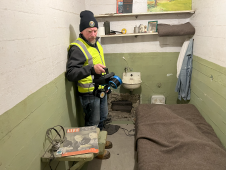
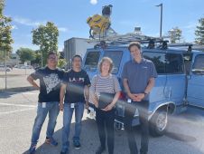
The rugged 22.5-acre site of the notorious US island prison Alcatraz has been digitally captured in a world-leading project involving multiple mapping technologies. With the team camped in the jail’s infamous cells for three weeks during the cold San Francisco winter, this historically, biologically and architecturally important location was recorded in unprecedented 3D detail. We discussed the project with project head Pete Kelsey and team member Dr Jeremy Sofonia. The rugged 22.5-acre site of the notorious US island prison Alcatraz has been digitally captured in a world-leading project involving multiple mapping technologies. With the team camped in the jail’s infamous cells...
Unicore Communications, Inc. is a high-tech company dedicated in high performance satellite positioning, multi-sensor fusion algorithm development, and highly integrated GNSS IC design. With the advantage of talent, management, technology...

Looking for a recipe for business success in surveying? Don't underestimate the importance of innovative surveying services, says Moritz Lauwiner. The latest measurement sensors and software, decades of collective experience...
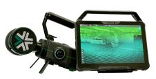
Exyn Technologies has unveiled Exyn Nexys, an innovative modular 3D mapping solution. Designed for professionals in the mining, construction, AEC and geospatial industries, Nexys aims to set a new standard...

The fourth edition of Geo Connect Asia (GCA), celebrated as the region's premier trade event and conference for the geospatial, positioning and remote sensing industries, truly delivered during its two-day...
SimActive has reported that the use of its Correlator3D product along with ground control points can enhance, extend and validate photogrammetry projects. GCPs are critical in photogrammetry projects, but there...
Lidar, short for Light Detection and Ranging surveying, represents a sophisticated measuring system leveraging the power of light. Widely recognized for its versatility, Lidar is extensively applied in diverse fields...
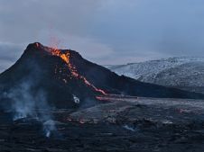
The Icelandic authorities have commissioned Acecore to map the extent and aftermath of the Eldvörp-Svartsengi volcanic system eruption using its high-end drone solutions. Grindavík, a fishing village on the Reykjanes...
Trimble has unveiled the integration of the Trimble Applanix POSPac Cloud post-processed kinematic (PPK) GNSS positioning service, featuring CenterPoint RTX, with the UAV-based mapping and data collection capabilities of DroneDeploy’s reality...
This site uses cookies. By continuing to use this website, you agree to our Cookies Policy. Agree