Found 1628 results
Sort by

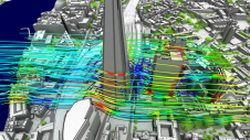
Using Lidar to enhance urban navigation data quality

At OxTS, in line with our brand promise of being inertial navigation experts, our commitment to our customers is that we will keep innovating until we can help them truly ‘navigate anywhere’ – with or without GNSS. We are advancing our products in that direction by first enhancing urban navigation data quality based on sensor fusion. Here, we explain how. At OxTS, in line with our brand promise of being inertial navigation experts, our commitment to our customers is that we will keep innovating until we can help them truly...

Read more

Lingli Zhu

Dr Lingli Zhu received her doctoral and master’s degrees in the field of Remote Sensing and Photogrammetry from Aalto University in 2015 and 2007, respectively. Currently, she is leading an...

Read more

UAV Remote Sensing for Smart Agriculture

‘Smart agriculture’, i.e. the efficient use of Earth's resources to feed the world, requires accurate and advanced data acquisition, modelling and management. UAVs can play a critical role in this....

Read more

Can digital twin techniques serve city needs?

Can digital twins help cities face challenges ranging from sustainability to education, and from infrastructure to healthcare? While digital twin techniques have been applied successfully in manufacturing and construction, cities...

Read more