Modelling the Erechteion
Modern terrestrial laser scanners (TLS) generate between 10 and 50 million 3D coordinates per minute: about 500Mbytes of data. Together with high-resolution images for texturing purposes, this is enough information...
Modern terrestrial laser scanners (TLS) generate between 10 and 50 million 3D coordinates per minute: about 500Mbytes of data. Together with high-resolution images for texturing purposes, this is enough information...
Autodesk's new Infrastructure Modelling software products facilitates users in utilities, telecommunications organisations and government agencies improve the design and management of their infrastructure. Autodesk's portfolio of products - including AutoCAD...
Simulation of sound propagation is key for today’s urbanised society, in which sound is omnipresent and often negatively affects people’s lives. Existing methods of sound-propagation modelling fail to capture the...
The recently completed Kentucky Watershed Modeling Information Portal (KWMIP), funded through a 750,000USD Co-operative Agreement with the US Environmental Protection Agency (EPA), is an innovative, standards-based data provisioning portal for...
The development of GIS and carto-graphy can be characterised as information rich and knowledge poor. That is, the amount of geospatial information collected using geospatial technologies, including remote sensing, global...

Arkadiusz Szadkowski is senior business development manager of reality mapping, imagery & remote sensing at Esri. He is passionate about leading the change towards 3D GIS and bridging the gap...
Both vertical and oblique aerial images have their own advantages, making them valuable in different reality mapping applications. So how can you choose between the two? This comparison will help...
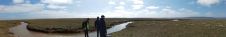
Coastal and estuarine saltmarsh has long been recognised as having key physical, ecological, and recreational value, acting as sediment and nutrient traps and as natural coastal protection structures functioning as...
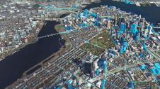
Bentley Systems, a leading global provider of comprehensive software solutions for advancing infrastructure, demonstrated at SPAR 3D Expo & Conference the latest ContextCapture offerings for reality modelling that increase joint opportunities in...
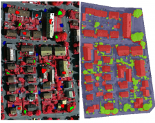
This article outlines a generic workflow for automatic buidling detection and 3D modelling using modern technologies, to support applications ranging from urban planning and cadastre to change detection and navigation....
This site uses cookies. By continuing to use this website, you agree to our Cookies Policy. Agree