Arkadiusz Szadkowski
Arkadiusz Szadkowski is senior business development manager of reality mapping, imagery & remote sensing at Esri. He is passionate about leading the change towards 3D GIS and bridging the gap...

Arkadiusz Szadkowski is senior business development manager of reality mapping, imagery & remote sensing at Esri. He is passionate about leading the change towards 3D GIS and bridging the gap...
Today’s photogrammetric software is able to create dense and precise digital surface models (DSMs), digital elevation models (DEMs) and orthoimages. But is the accuracy sufficient for highly demanding railway applications?...
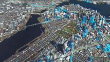
Both vertical and oblique aerial images have their own advantages, making them valuable in different reality mapping applications. So how can you choose between the two? This comparison will help...
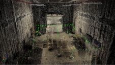
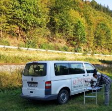
Swiss engineering and geomatics consulting firm Mosini Caviezel SA has been testing terrestrial photogrammetry for indoor mapping as a new method for establishing property plans. The company is evaluating the...
Photogrammetry has made huge progress over the past 15 years, on both hardware and software fronts. Dedicated large-frame cameras enable increasingly high geometric and radiometric precision, capturing overlapping images to...
It can still be difficult to achieve centimetre-level accuracy in mobile mapping, especially in GNSS-denied or challenging areas such as in deep urban canyons, under foliage or through tunnels. However,...
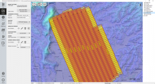
The TatukGIS Developer Kernel (DK) plays a key role in the Topoflight software suite (Missionplanner for optimal flight paths, and Navigator for precise data acquisition). In the realm of vast...

Recently unveiled by Vexcel Imaging, the groundbreaking UltraCam Dragon 4.1 represents one of the market's most advanced, progressively designed and seamlessly integrated hybrid aerial mapping systems. Tailored for high-resolution mapping...
Is it possible to enhance point cloud accuracy and density by merging Lidar with photogrammetry technologies? Lidar data can penetrate trees and measure shadow areas to produce a very accurate...
This site uses cookies. By continuing to use this website, you agree to our Cookies Policy. Agree