Benefits of GIS in Urban Planning
Traditional methods of information management are hard to use in the planning process of problematic urban areas such as squatter settlements. GIS provides the capability for dynamic query and analysis,...
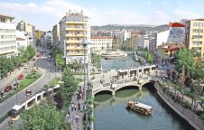
Traditional methods of information management are hard to use in the planning process of problematic urban areas such as squatter settlements. GIS provides the capability for dynamic query and analysis,...
Increasingly frequent disasters with attendant damage have heightened climate change related environmental and social vulnerability, emphasising the need for tools to support disaster management. In South Africa a National Disaster...
In Lombardy (Italy) one has started a project on risk-assessment of buildings of historical-architectural importance. For this purpose a Building Information System (BIS) has been created, based on archived and...
Optech Incorporated focuses on the development, manufacture and support of advanced, lidar-based survey solutions. Established in 1974 as a privately held, Canadian-owned research and development firm, Optech was originally an...
There is general agreement that spatial data is key to sustainable resource management and overall economic development. A Spatial Data Infrastructure (SDI) in turn provides the underlying foundation for accessing...
For the past ten years, the International Organization for Standardization (ISO) Technical Committee 211, Geographic information/Geomatics has been working on standards development. It is now completing an initial set of...
Disasters are of all ages. When they strike, more often than not they strike suddenly and ruthlessly. The damage disasters cause fills us with deep awe for the unimaginable forces...
A beam coming from the instrument. Aim it at a surface and push the button, and the distance is measured by laser. Reflectorless laser distance measurement, <i>I know what it...
Medical applications such as bedsore analysis often require 3D surface reconstruction of the human body. Major surface reconstruction techniques are based on mechanical digitizers, laser scanners and vision systems, including...
The internationally supported African initiative Africa Reference Framework project (AFREF) aims at using GNSS to unify the coordinate reference systems within Africa to produce a uniform and consistent coordinate system...
This site uses cookies. By continuing to use this website, you agree to our Cookies Policy. Agree