SIIS Enters Satellite Imagery Partnership with SkyFi
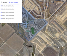
SI Imaging Services (SIIS) has expanded its array through a new partnership agreement with satellite imaging platform company SkyFi which gives SkyFi access to SIIS’s VHR Korean Multi-Purpose Satellite (KOMPSAT)...