Stonex
Stonex is an Italian company, world leader in measurement and surveying. The head office is near Milan and the American headquarters is in Concord, USA. The company also has a...

Stonex is an Italian company, world leader in measurement and surveying. The head office is near Milan and the American headquarters is in Concord, USA. The company also has a...

Global reference systems such as the International Terrestrial Reference Frame provide the foundation for determining positions on Earth and in space, as well as for reliably quantifying our planet’s changes...

GrabMaps is preparing to launch KartaCam 2, a crowdsourced mapping solution combining high-end imagery and AI capabilities to transform local expertise into effective navigation solutions. With the introduction of enhanced...

Over the past 20 years, various initiatives have been launched reflecting the importance of cadastral data for land management and spatial development. But how have these initiatives enhanced the possibility...

Dublin City University (DCU) has partnered with Bentley Systems to spearhead the creation of an advanced digital twin of its campus as a pivotal element of its Smart DCU initiative....
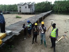
Incorporating smart methodologies in cadastral surveying is improving the land acquisition system in Ghana. Traditional cadastral surveying is time-consuming and, if not planned out well, could cost a fortune to...
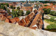
Lidar-powered Matterport technology was employed to create a 3D digital twin of the most famous inhabited bridge globally, the Krämerbrücke, situated in the city of Erfurt, Thuringia, Germany. The Krämerbrücke...
Innovative methodologies based on artificial intelligence (AI) are lowering the barriers and democratizing the use of 3D digital twins in the geospatial industry. Digital twins are revolutionizing the geospatial industry,...
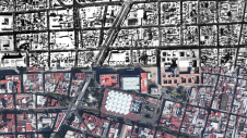
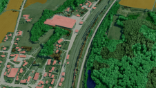
Over the past 15 years, geospatial information has enabled the transformation of towns, cities and a whole state in Mexico. The customer and data provider teamed up to create up-to-date...
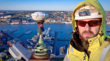
The revolutionary use of active GNSS control points and cutting-edge geomatics equipment is setting new standards for accuracy in the construction of high-rise architecture, as demonstrated by this skyscraper project...
This site uses cookies. By continuing to use this website, you agree to our Cookies Policy. Agree