Sharing
The first impulse when you meet someone poor or suffering whilst you yourself are prosperous is to give bits and pieces, usually in the abstract form of coins or bank...
The first impulse when you meet someone poor or suffering whilst you yourself are prosperous is to give bits and pieces, usually in the abstract form of coins or bank...
The eighth in the series of annual Map India conferences was organised for the first time this year jointly with the Indian Society of Geomatics (ISG). The event took place...
In November 2004 an Expert Group Meeting on Secure Land Tenure was held at UN Headquarters in Nairobi, Kenya. The focus of this meeting was to discuss new legal frameworks...
In November 2004 an Expert Group Meeting on Secure Land Tenure was held at UN Headquarters in Nairobi, Kenya. The focus of this meeting was to discuss new legal frameworks...
Surveyors working on busy roads are constantly subjected to close misses from passing traffic; it can be worse. Helicopter photogrammetry is a survey technique designed to prevent fatalities. A complete,...
SmartTech was established in 1996 in Cape Town, South Africa by the current president, Spencer Allen. The company is dedicated to the development of software for surveyors, photogrammetrists and related...
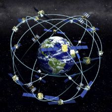
Receiver position is calculated from the position of satellites and the distances to them. Distance is calculated from the time a radio signal travels between satellite and receiver. But how...
Developments in geo-technology move almost faster than a ray of light and as a consequence the daily work of a surveyor has been changing dramatically over recent years. Digitalisation of...
The pan-European research platform EuroSDR (European Spatial Data Research) will host a forthcoming international conference on merging map data from different sources, especially the satellite-based GPS. The conference, “Achieving geometric...
Aerial photography company BlueSky (UK) has created a series of contour maps, terrain models and perspective views from archived black and white aerial photography to aid site and infrastructure development...
This site uses cookies. By continuing to use this website, you agree to our Cookies Policy. Agree