3D Modelling from RGB Images
FOVEX Measure 3D is a combination of a super-fast high-resolution 360° panorama camera and innovative software that allows accurate measurement and CAD modelling directly within the images. FOVEX Measure 3D...
FOVEX Measure 3D is a combination of a super-fast high-resolution 360° panorama camera and innovative software that allows accurate measurement and CAD modelling directly within the images. FOVEX Measure 3D...
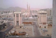
The city of Medina in the Kingdom of Saudi Arabia is realising base maps and 3D modelling. In order to provide the necessary services, Blom CGR, the Italian subsidiary of...
A seminar on 3D urban modelling and ways in which it can be implemented into your working life is being organised by aerial photography company Getmapping. Held at Bath Spa...

Amuse oneself Inc., established in 2011, develops hardware and software for 3D measurements required for ICRT technology (Information, Communication and Robot Technology). Since our successful commercialization of the world’s first...
Terrestrial laser scanning is becoming increasingly important as the software and technology-related developments in many spheres of society mean that ever-higher standards are being set in terms of quality and...
Leica Geosystems, part of Hexagon, has launched the Leica TerrainMapper-3 airborne Lidar sensor, featuring new scan pattern configurability to support the widest variety of applications and requirements in a single...
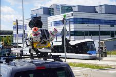
Trimble has recently unveiled the Trimble MX90 mobile mapping system. Integrating advanced Trimble GNSS and inertial technology with Trimble field and office software, the MX90 offers a comprehensive field-to-finish mobile...

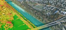
Accurate digital representations of cities are game changers in urban development. By enabling virtual modelling and smart simulations, they allow decision-makers to explore, test and assess the measures taken. Hosted...
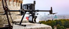
3D Target has continued to make significant advancements since launching its inaugural Scanfly model at Intergeo in 2016, at a time when Lidar technology in the UAV industry was still...

Newcastle University, UK, is developing advanced computer modelling to assess the flood risk of individual properties using Lidar data and oblique aerial photography from Bluesky. The project will use artificial...
This site uses cookies. By continuing to use this website, you agree to our Cookies Policy. Agree