Trackair Ltd Aerial Survey
Make Underwater Exploration Easier Focus on acoustic sounding technology, Hydro-Tech had developed different products widely applied in underwater exploration industry. Nowadays Hydro-Tech owns completely independent and controllable core technologies in...
Infoterra France and their Greek partner GEOMET Ltd have won a major contract, worth over €2.86 million, to deliver a significant quantity of fully orthorectified imagery and Digital Surface Models...

The Icelandic authorities have commissioned Acecore to map the extent and aftermath of the Eldvörp-Svartsengi volcanic system eruption using its high-end drone solutions. Grindavík, a fishing village on the Reykjanes...
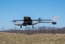
In a new strategic partnership, Inertial Labs' RESEPI Payload Lidar technology will be integrated into E38's advanced E455 drone platform. This collaboration marks a significant milestone in the utilization of...
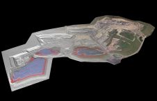
At Geo Week 2024 in Denver, Maptek unveiled its latest innovation: Maptek GeoSpatial Manager. This groundbreaking solution simplifies and streamlines workflows, revolutionizing how mining and civil engineering projects manage data...
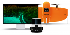
Wingtra has unveiled its innovative Lidar-drone solution. The new Lidar payload is designed to seamlessly integrate the efficiency, ease of operation, and high accuracy of the WingtraOne GEN II drones...
This site uses cookies. By continuing to use this website, you agree to our Cookies Policy. Agree