Amuse Oneself
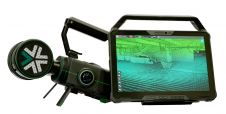
Amuse oneself Inc., established in 2011, develops hardware and software for 3D measurements required for ICRT technology (Information, Communication and Robot Technology). Since our successful commercialization of the world’s first...

Amuse oneself Inc., established in 2011, develops hardware and software for 3D measurements required for ICRT technology (Information, Communication and Robot Technology). Since our successful commercialization of the world’s first...

Klau Geomatics has introduced the Brumby RTK Lidar system, an innovative mobile mapping solution equipped with powerful Edge Compute capabilities, enabling the generation of highly precise georeferenced point clouds in...

Trimble has recently unveiled the Trimble MX90 mobile mapping system. Integrating advanced Trimble GNSS and inertial technology with Trimble field and office software, the MX90 offers a comprehensive field-to-finish mobile...

Calling all professionals! Please contribute to the 2024 edition of the annual geospatial industry survey by GIM International, which is currently in progress. This yearly tradition serves as a valuable...
Exyn Technologies has unveiled Exyn Nexys, an innovative modular 3D mapping solution. Designed for professionals in the mining, construction, AEC and geospatial industries, Nexys aims to set a new standard...

EuroGeographics is drawing attention to the indispensable role of official national geospatial data in enhancing Copernicus Services, particularly within land monitoring and emergency management. This highlights a reinforced partnership between...

RIEGL has announced the launch of two innovative topobathymetric scanners. These advancements mark a shift towards enhanced efficiency and precision in data collection across land and water interfaces. The RIEGL...

Land Information New Zealand has made 20TB of aerial imagery available for free for the first time in a cloud-optimized format on Amazon Web Services (AWS), making it easier and...
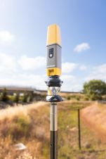
Topcon Positioning Systems has presented the latest addition to its HiPer family of global navigation satellite system (GNSS) receivers. The HiPer CR is a compact and lightweight GNSS receiver designed...

The EAASI Summit 2023 in Lisbon in November was a resounding success. While the aerial surveying association’s fifth annual gathering highlighted the growing unity within the industry, there was also...
This site uses cookies. By continuing to use this website, you agree to our Cookies Policy. Agree