JOUAV unveils advanced airborne Lidar sensor
JOUAV has released the JoLiDAR-1000 Lidar sensor designed specifically for uncrewed aerial vehicles (UAVs or ‘drones’) as the latest addition to its array of high-performance Lidar sensors for use in...
JOUAV has released the JoLiDAR-1000 Lidar sensor designed specifically for uncrewed aerial vehicles (UAVs or ‘drones’) as the latest addition to its array of high-performance Lidar sensors for use in...
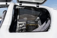
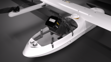
Diamond Aircraft and Vexcel Imaging have announced the next collaboration for a further expansion of Diamond’s special mission aircraft high-end sensor portfolio. The partnership will integrate the UltraCam Dragon 4.1...

Visitor registration is now open for GEO Business, the UK's largest geospatial event. The free-to-attend expo, tailored for geospatial professionals seeking to harness the potential of location intelligence, will return...

Sven Cowan is NV5 Geospatial’s Programme Manager for Canada. He has over 20 years of experience in customer-facing positions within the geospatial information industry and has worked for multiple geospatial...

Mosaic has partnered with Movella aimed at redefining precision and efficiency in mapping and 3D reconstruction projects. Mosaic is specialized in mobile mapping camera systems, while Movella is a renowned...

A topobathymetric Lidar survey was conducted to support flood preparedness in Canada. Which techniques achieved exceptional precision, and what were the logistical challenges? Find out more in this article. As...
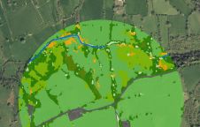
The UK’s Peak District National Park Authority is pioneering the use of artificial intelligence (AI) to automate the production of highly detailed land cover maps, in a project in partnership...
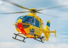
In a high-flying endeavour spanning over six decades, the UK’s National Grid's fleet of advanced helicopters have been diligently patrolling pylons and power lines, ensuring the health and reliability of...

Recently unveiled by Vexcel Imaging, the groundbreaking UltraCam Dragon 4.1 represents one of the market's most advanced, progressively designed and seamlessly integrated hybrid aerial mapping systems. Tailored for high-resolution mapping...
TatukGIS (Poland) has announced the release of the version 2.0 upgrade of the Aerial Imagery Correct product for rectifying, georeferencing, mosaicing aerial photos, satellite images, and scanned maps to geographical...
This site uses cookies. By continuing to use this website, you agree to our Cookies Policy. Agree