Usage of UAVs for flat roof drainage calculations
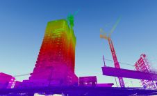
Modelling of urban areas, with emphasis on flat roof drainage calculations, is one application field in which the use of UAVs has significantly increased in recent years. A calibration base,...

Modelling of urban areas, with emphasis on flat roof drainage calculations, is one application field in which the use of UAVs has significantly increased in recent years. A calibration base,...

Land Surveying Drone solutions collect accurate, geo-tagged data quickly, while photogrammetry software processes these data to deliver standardized outputs. Learn how drones elevate land surveying Urban Planning Drone data creates...

Following its emergence more than a decade ago, digital twin technology has developed to become a complex and comprehensive technical system that supports the construction of new smart cities. It...

Why are UAVs increasingly supplementing or even replacing terrestrial survey methods for many applications? This article explores the advantages of photogrammetric mapping with UAVs. Unmanned aerial vehicle (UAV or 'drone')...

Despite having to improvise, this year’s pioneering digital edition of Intergeo has received a lot of positive feedback. It became the international geospatial industry’s first-ever online-only event after the COVID-19...

SimActive has announced the release of Correlator3D version 8.6. The new version includes multiple new features, such as the use of intensity data from LAS files for image registration, the...
When it comes to 3D modelling for construction, what are the advantages and disadvantages of photogrammetry versus Lidar in terms of accuracy, complexity and cost? Breaking away from laser measurement...

With the 3D models generated from DJI Terra and P4 RTK, a Japanese city can now create digital twins and preserve every little detail on the construction of a centuries-old...
GeoSLAM has partnered with UK-based drone specialist Heliguy to provide professionals with sophisticated aerial mapping solutions. Drones have become a crucial tool for collecting accurate survey data quickly and safely, also...

Emesent has announced a major breakthrough in the journey to fully autonomous flight systems, with the launch of Autonomy Level 2 (AL2) technology for Hovermap, a plug-and-play payload for industrial...
This site uses cookies. By continuing to use this website, you agree to our Cookies Policy. Agree