Mapping & GIS - Forestry Department HQ

1Spatial has successfully secured a three-year contract with a leading distribution system operator for electricity and gas networks in Belgium. The contract, awarded after a competitive tender process, will involve...
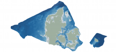
Through the collaborative implementation of satellite-derived bathymetry (SDB), the Danish Geodata Agency and EOMAP are synergizing efforts to contribute to the European Marine Observation and Data Network (EMODnet) Bathymetry partnership....

GrabMaps is preparing to launch KartaCam 2, a crowdsourced mapping solution combining high-end imagery and AI capabilities to transform local expertise into effective navigation solutions. With the introduction of enhanced...

The EAASI Summit 2023 in Lisbon in November was a resounding success. While the aerial surveying association’s fifth annual gathering highlighted the growing unity within the industry, there was also...

CoreLogic, a leading global property information, analytics and data-enabled solutions provider, has announced the launch of its new publicly-accessible risk information resource centre, Hazard HQ. This new information hub will offer...
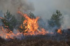
The number of wildfires has increased dramatically in recent years due to diminishing forest health caused by the drastically changing climate across the world. Longer dry-weather periods and pressure from a variety of pests and diseases, e.g. bark beetles, are affecting the large forest areas in Northern Europe. In addition to financial losses, these impacts are resulting in lower carbon accumulation and vast ecological changes. The number of wildfires has increased dramatically in recent years due to diminishing forest health caused by the drastically changing climate across the world. Longer dry-weather periods and pressure from...

Hemisphere GPS and AgSync, Canada, have announced their partnership and the release of HQ Sync: a bridge between the Hemisphere GPS HQ real-time web-based asset-tracking tool and the AgSync work-order...
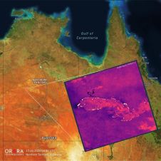
UP42 and OroraTech have signed a partnership agreement to grant easy and fast access to global high-resolution thermal-infrared imagery. UP42 is a geospatial developer platform and marketplace, and OroraTech is...
This site uses cookies. By continuing to use this website, you agree to our Cookies Policy. Agree