Vodafone Creates Digital Twin of UK Mobile Mast Network
Vodafone has partnered with Esri to create a digital twin of its network of mobile masts. This will enable real-time monitoring of the network, helping to ensure the best possible...
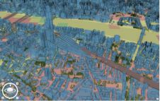
Vodafone has partnered with Esri to create a digital twin of its network of mobile masts. This will enable real-time monitoring of the network, helping to ensure the best possible...

Besides its excellent technical content, the recent FIG Congress in Poland was a place for enthusiastic reunions and for forming new friendships. Wim van Wegen looks back on the event,...

OHLA has recently unveiled details of the Lund-Arlöv project (Sweden), where it has carried out one of Europe's most advanced digitization projects. The details were revealed at the recent Esri...

Background In December 2019, the municipal government of Kalmar, Sweden, embarked on an EU-funded StreamSam initiative to digitize its community development process. The StreamSam project is creating a 3D digital...
A national mapping agency in Europe needed to create a 3D digital twin of its entire country from a collection of geospatial data in varying scales and formats. A primary...

Local indigenous youngsters in northern Colombia have mapped the boundaries and sacred sites of their village, Gunmaku in the Sierra Nevada of Santa Marta, and the indigenous authorities are happy...

Kadaster, the Dutch bureau of land management, is organizing a symposium on ‘Bringing networks and knowledge into practice’ on 1 September 2022. This symposium will also include a farewell session...

Woolpert has been selected to collect, process and deliver topographic mapping across more than one quarter of Nigeria, or roughly 258,000 square kilometres, under a US$4.4 million contract with the...

Only a small fraction of the information content in aerial films has ever been recorded on paper maps, most of which are inaccessible. The use of artificial intelligence (AI) to...

Integrated airborne sensing combining imagery and Lidar data presented an effective solution in this complex project to model two iconic Croatian cities with challenging relief and landscape. Nowadays, both image-based...
This site uses cookies. By continuing to use this website, you agree to our Cookies Policy. Agree