Navigation 2.0
Navigation is a daily activity for many as they move from place to place. With increasing complexity in transportation networks has come a rising demand for navigational assistance. Over the...
Navigation is a daily activity for many as they move from place to place. With increasing complexity in transportation networks has come a rising demand for navigational assistance. Over the...
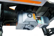
The AlphaUni 20 (AU20) Lidar system represents a new era in cost-effective, multi-platform mobile mapping solutions, according to CHC Navigation (CHCNav), a global leader in precision mapping, positioning and navigation...
Unicore Communications, Inc. is a high-tech company dedicated in high performance satellite positioning, multi-sensor fusion algorithm development, and highly integrated GNSS IC design. With the advantage of talent, management, technology...

The European Investment Bank (EIB) and NavVis have signed a contract which provides financing of €20 million to NavVis, a global market leader in digital twin technology. NavVis has experienced...
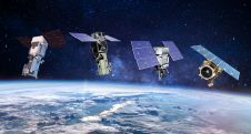
European Space Imaging and Space Imaging Middle East have extended their long-standing partnership with Maxar Technologies to continue acquiring and supplying very high resolution satellite imagery to Europe, North Africa...

Looking for a recipe for business success in surveying? Don't underestimate the importance of innovative surveying services, says Moritz Lauwiner. The latest measurement sensors and software, decades of collective experience...

Despite some uncertainty, there is renewed interest in drones, and remote sensing technologies are being embraced by smaller survey companies. Read these and other findings from our annual industry survey!...

NavVis recently unveiled a substantial enhancement in global 3D spatial technology access and performance. By launching new cloud regions in the Americas and Asia-Pacific (APAC), the company aims to elevate...
This site uses cookies. By continuing to use this website, you agree to our Cookies Policy. Agree