GIS portal enhances collaboration for UK nuclear power station
EDF, a French electric utility company, has partnered with Esri UK to implement an enterprise GIS for Hinkley Point C (HPC) nuclear power station, one of the largest and most...
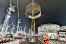
EDF, a French electric utility company, has partnered with Esri UK to implement an enterprise GIS for Hinkley Point C (HPC) nuclear power station, one of the largest and most...

Bluesky Geospatial has announced the launch of its MetroVista 3D aerial mapping programme in the USA. The service employs a hybrid imaging-Lidar airborne sensor to capture highly detailed 3D data,...

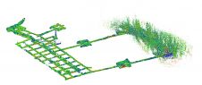
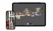
Researchers from the Oxford Robotics Institute (ORI) have developed a lightweight, handheld device that can create accurate 3D maps of entire buildings in a matter of hours. The device combines...
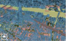
Vodafone has partnered with Esri to create a digital twin of its network of mobile masts. This will enable real-time monitoring of the network, helping to ensure the best possible...
A RIEGL VZ-400i 3D terrestrial laser scanner was deployed in Peru to create a high-resolution digital 3D terrain model of an ancient fortress. This is a good example of how...
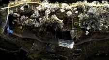
Read how SLAM technology was used to scan a former mine complex in Poland to ensure safety during a project to preserve the site's historical, educational and functional significance. Underground cultural...
FARO Technologies has announced the acquisition of SiteScape. An innovator in Lidar 3D scanning software solutions for the AEC and O&M markets, SiteScape enables Lidar-equipped mobile devices to easily capture...

Carlos Bausá Martínez is a Spanish architect and energy assessor who is based and ARB-registered in the UK. He specializes in urban and architectural environmental analysis and computational design. He...
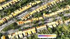
Improved understanding of the amount of solar energy that could be gathered directly from roofs can support the complex task of transitioning existing low-density residential areas to renewable energies. A...

Bluesky International has been named as one of the selected organizations to sit on a new framework created by Ordnance Survey. The Remote Sensing Acquisition Framework has been set up...
This site uses cookies. By continuing to use this website, you agree to our Cookies Policy. Agree