GIM - Issue 2-2024
Presenting the latest developments in aerial mapping, products and services. Intriguing real-life projects provide insights into advanced aerial photogrammetry and Lidar in practice. Moreover, this edition looks at how AI...

Presenting the latest developments in aerial mapping, products and services. Intriguing real-life projects provide insights into advanced aerial photogrammetry and Lidar in practice. Moreover, this edition looks at how AI...
Geo Week is the premier event for increased integration between the built environment, advanced airborne/terrestrial technologies, and commercial 3D technologies. It was created as a response to the changing needs of built world...

GEO Business, the UK’s premier geospatial event, is celebrating its tenth anniversary when it returns to ExCeL London on 5 and 6 June 2024. This edition promises to be the...
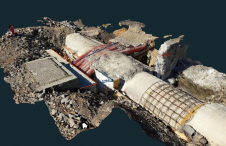
Videogrammetry can be seen as a natural progression from photogrammetry. So how can videogrammetry improve and enhance data collection for surveying professionals? This article explores its intricacies through case studies,...

The 12th International FIG Workshop on the Land Administration Domain Model & 3D Land Administration will take place in Kuching, Malaysia, 24-26 September 2024. It will be a joint event together...
The launch of ISRO`s Polar Satellite Launch Vehicle (PSLV-C15), with Cartosat-2B as one of the satellites to orbit during its mission, fixed for 9th May 2010 has been rescheduled. The...

PlanetObserver has unveiled the PlanetSAT Global Basemap 2024, aiming to enhance geospatial data applications across various industries. The latest iteration of this renowned basemap provides users with up-to-date, cloud-free and...

Just over a week after being lofted into orbit, the European Union’s Sentinel-2B satellite delivered its first images of Earth, offering a glimpse of the ‘colour vision’ it will provide for...

The ESA-developed Sentinel-2B satellite has been launched. This doubles the coverage of high-resolution optical imaging in the Sentinel-2 mission for the European Union Copernicus environmental monitoring system. The 1.1 tonne...
This site uses cookies. By continuing to use this website, you agree to our Cookies Policy. Agree