Hemisphere GPS R320 - Eclipse II Dual Frequency GNSS Receiver
Hemisphere GPS has announced the release of R320 - the first GNSS receiver built on Hemisphere GPS' new Eclipse II OEM board. Using the latest GNSS patented technology, R320 offers...

Hemisphere GPS has announced the release of R320 - the first GNSS receiver built on Hemisphere GPS' new Eclipse II OEM board. Using the latest GNSS patented technology, R320 offers...

Urs Hugentobler is a professor of Satellite Geodesy and heads the Satellite Geodesy Research Facility of the Technical University of Munich, which operates the Geodetic Observatory Wettzell together with the...

Global reference systems such as the International Terrestrial Reference Frame provide the foundation for determining positions on Earth and in space, as well as for reliably quantifying our planet’s changes...
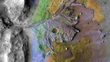
Using ground-penetrating radar, NASA’s Perseverance rover has uncovered compelling evidence of ancient lake sediment on Mars. This confirms the longstanding hypothesis that the Red Planet was once a warm, wet...

Harxon demonstrated its dedication to innovation at Intergeo 2023 by introducing two products designed to advance high-accuracy positioning within the geospatial industry: the Survey GNSS Antenna (HX-CSX600A) and the Helix...

Lidaretto is flexible and compact Lidar scanning system developed since 2015 and uniquely designed to be used the way that fits best to users’ specific application. You can easily mount...
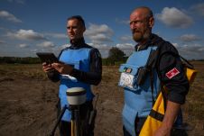
Trimble has announced a partnership with the HALO Trust, the world’s largest landmine-clearing non-profit organization, to help expand its demining operations across Ukraine. The grant from the Trimble Foundation Fund...
Hemisphere GPS has reported their financial results for the fourth quarter and year ended 31st December 2008. The company achieved a 35% increase in revenues to a record of USD72.7...
Hemisphere GPS (Canada) has entered into a definitive agreement with BEELINE Technologies Pty Ltd. under which Hemisphere GPS has agreed to acquire all of the outstanding shares and ongoing operations...

Land Information New Zealand has made 20TB of aerial imagery available for free for the first time in a cloud-optimized format on Amazon Web Services (AWS), making it easier and...
This site uses cookies. By continuing to use this website, you agree to our Cookies Policy. Agree