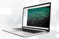
MicaSense Atlas Integrated with Pix4D Software
MicaSense Atlas is now integrated with Pix4D desktop software. This new partnership is designed to offer MicaSense customers the power of desktop processing, as well as the flexibility of MicaSense...
MicaSense Atlas is now integrated with Pix4D desktop software. This new partnership is designed to offer MicaSense customers the power of desktop processing, as well as the flexibility of MicaSense...
Both vertical and oblique aerial images have their own advantages, making them valuable in different reality mapping applications. So how can you choose between the two? This comparison will help...

Intergeo 2023 was an electrifying three-day event in Berlin, transforming the city into the global geospatial capital. From 10-12 October, professionals from across the globe convened for the world’s premier...
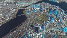
How can city digital twins support the attainment of SDG11? They can be used to manage infrastructures (e.g. roads, transportation and public services, smarter energy grids and water networks), support...
In this exclusive interview, two of the driving forces behind this year's Intergeo talk about the event's evolution and impact, nurturing talent, land surveying, Earth observation and the Blue Economy....

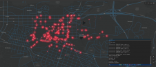
Driving new opportunities in the mapping landscape, a significant milestone has been achieved in New Zealand. With the introduction of 3D mapping data for the Waikato and Southland regions, access...

It is time to innovate with technology that can be applied ‘right here, right now’. That was the clear message during HxGN LIVE Global 2023. President and CEO Paolo Guglielmini...

Trimble has announced the opening keynote speaker for its 2023 Trimble Dimensions Conference: Formula 1’s Mark Gallagher. The conference features three days of fast-paced education, innovation and networking with Trimble...

As the host city of Intergeo 2023 this October, Berlin promises to deliver the perfect kick-start for the geospatial industry in these rapidly changing times. The vibrant German capital is...
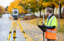
Although the essence of surveying has barely changed since the profession began, the increasingly complex digital continuum requires geospatial professionals to adapt their skills in dynamic and important ways, writes...
This site uses cookies. By continuing to use this website, you agree to our Cookies Policy. Agree