SBAS Construction Site Safety Trial Holds Promise
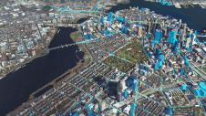
Safe Work Australia found that 31% of construction workers’ injuries on the job were from being hit by an object and have trialled the use of SBAS (satellite-based augmentation system)...

Safe Work Australia found that 31% of construction workers’ injuries on the job were from being hit by an object and have trialled the use of SBAS (satellite-based augmentation system)...

Luminous Group, the 3D technology specialists, has launched its new RIVO software using mixed reality solutions to transform asset mapping for the oil and gas, facilities management and construction industries....
Both vertical and oblique aerial images have their own advantages, making them valuable in different reality mapping applications. So how can you choose between the two? This comparison will help...
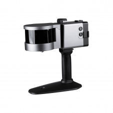
ComNav has announced the launch of its latest innovation: the LS300 3D laser scanner. This addition to the company's product lineup signifies a significant leap forward in addressing the dynamic...
Intergraph’s Security, Government & Infrastructure (SG&I) division has rebranded globally as Hexagon Safety & Infrastructure. The new name more closely aligns the business and its industry-leading solutions with parent company...

Geomaat, a Dutch company specialised in geodetic survey services, has developed a method of measuring safety barrier heights on European roads. The system uses StreetMapper, 3D Laser Mapping’s mobile laser...
Project S04B, Mobile Data Collection contract from SHRP 2 (Strategic Highway Research Program 2), has been awarded to Fugro Roadware and is valued at over USD3 million and spans 2...
Esri launched a enterprise licensing program to make acquiring Esri technology affordable for small public safety agencies. The Small Public Safety (SPS) Enterprise License Agreement (ELA) gives fire, law enforcement,...
Clark Nexsen, an architecture and engineering firm headquartered in Norfolk, VA, USA, improved the efficiency and safety of a highway maintenance survey by using GPS-Photo Link photo-mapping software from GeoSpatial...

Thousands of planes are grounded across Europe due to the spread of volcanic ash following the recent eruption under Iceland's Eyjafjallajoekull glacier. Volcanic eruptions eject large amounts of ash and...
This site uses cookies. By continuing to use this website, you agree to our Cookies Policy. Agree