ScanMaster 2.0
Topcon has announced the release of ScanMaster 2.0 software which is faster and more powerful than previous versions. This new software saves time and increases the productivity on every job,...
Topcon has announced the release of ScanMaster 2.0 software which is faster and more powerful than previous versions. This new software saves time and increases the productivity on every job,...
Navigation is a daily activity for many as they move from place to place. With increasing complexity in transportation networks has come a rising demand for navigational assistance. Over the...
We all know about the rapid evolution in world mapping. While mapping was long the domain of skilled mapmakers, nowadays it is increasingly in the hands of the lay public,...

Dublin City University (DCU) has partnered with Bentley Systems to spearhead the creation of an advanced digital twin of its campus as a pivotal element of its Smart DCU initiative....

Jonathan Arthur Quaye-Ballard is a professor and head of the Department of Geomatic Engineering at KNUST, where he has worked for the past 20 years. He also holds a BSc...
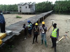
Incorporating smart methodologies in cadastral surveying is improving the land acquisition system in Ghana. Traditional cadastral surveying is time-consuming and, if not planned out well, could cost a fortune to...
GE Energy has announced the availability of its Smallworld Analysis and Optimization 4 (A&O) product for the electric utility design market. The product allows users to take advantage of advanced...
GE Energy (GA, USA) has announced that Entergy Corporation (LA, USA) has expanded its implementation of the Smallworld geospatial software product suite by selecting the Cornerstone Gas Productivity Pack for...
SimActive has announced that users of LiDARUSA's multi-sensor systems can now take advantage of SimActive's Lidar point cloud colourization capabilities. Using SimActive's Correlator3D software, users can integrate Lidar data and...
Linkfast Technology of Taiwan has joined the Pointools Partner Programme in Asia. Pointools software is used by project teams to reference and reuse the largest point-cloud models in the broadest...
This site uses cookies. By continuing to use this website, you agree to our Cookies Policy. Agree