Enterprise GIS Award for Abu Dhabi Police
The Abu Dhabi Police (ADP) received the prestigious Esri Enterprise GIS Vision Award in recognition of its Esri platform that improves key areas, such as crime prevention, security and emergency...

The Abu Dhabi Police (ADP) received the prestigious Esri Enterprise GIS Vision Award in recognition of its Esri platform that improves key areas, such as crime prevention, security and emergency...
Shengli Engineering and Consulting Company Limited (SLECC), a registered survey and engineering institute in China, has chosen Intergraph SmartPlant Enterprise solutions, including SmartPlant 3D, to execute its design and engineering...
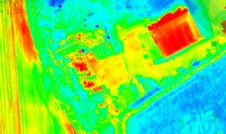
Topodrone has recently unveiled a cutting-edge drone thermal mapping solution: the Topodrone PT61 camera, designed to conduct detailed surveys and generate thermal orthomosaic maps, facilitating the creation of accurate 3D...
ESRI has announced that Navteq has signed an enterprise license agreement for the ESRI ArcGIS suite of software products. This worldwide agreement allows Navteq to utilise ArcGIS technology across the...
Leica Geosystems Geospatial Imaging (GA, USA) has released RedSpider Enterprise 3.5.2. With numerous enhancements, RedSpider Enterprise has increased its compliance with the Open Geospatial Consortium and International Organization for Standardization...
Definiens (Germany) has made available version 7 of the Definiens Enterprise Image Intelligence Suite. The latest version of this image analysis platform integrates automated image intelligence with GIS, providing a...
Autodesk, Inc. (CA, USA) has unveiled Autodesk MapGuide Enterprise 2008 and Autodesk Topobase 2008 software products, two platforms to share location, design and enterprise information across departments. Autodesk MapGuide Enterprise...
Newmont Mining Corporation has selected ESRI as its enterprise GIS software provider. Newmont Mining is the second largest gold producer in the world, with operations on five continents. The global...
STAR INFORMATIC (Belgium) announces its commitment to the Open Spatial Enterprise approach for the native storage of data in Oracle Spatial and Locator format for both Oracle9i and Oracle Database...

In the rapidly evolving landscape of geospatial technology, the annual Trimble Dimensions gathering is a dependable beacon for the surveying and mapping fields, providing a panoramic view of the current...
This site uses cookies. By continuing to use this website, you agree to our Cookies Policy. Agree