Arrowhawk Imaging Selects Ultracam Eagle for Aerial Mapping
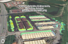
Arrowhawk Imaging has selected an UltraCam Eagle Mark 3 aerial camera system with a 100mm lens as its first airborne imaging system. Since purchasing the sensor from Vexcel Imaging in...

Arrowhawk Imaging has selected an UltraCam Eagle Mark 3 aerial camera system with a 100mm lens as its first airborne imaging system. Since purchasing the sensor from Vexcel Imaging in...

Applanix, a Trimble company, has announced the Trimble AP+ Land GNSS-inertial OEM solution for accurate and robust position and orientation for georeferencing sensors and positioning vehicles in land mobile mapping...

RIEGL has recently released its software suite for processing kinematic Lidar data: RiPROCESS 1.9.2. The software and the associated tools provide additional benefits for processing RIEGL kinematic laser scan data....

In the wake of Hurricane Henri and Hurricane Ida, Applanix, a Trimble Company, and NOAA recently collaborated to provide critical information to first responders. Applanix’s high-accuracy direct georeferencing (DG) technology...

Powerhouses of photogrammetry and remote sensing science and industry are set to gather in Nice, France, for the XXIV Congress of the International Society for Photogrammetry and Remote Sensing (ISPRS) from 6-11 June 2022. Powerhouses of photogrammetry and remote sensing science and industry are set to gather in Nice, France, for the XXIV Congress of the International Society for Photogrammetry and Remote Sensing (ISPRS)...

Microdrones has taken yet another step forwards in drone solutions for aerial surveying, inspection and other mapping applications. The company’s new mid-market quadcopter system, the mdLiDAR1000LR, flies higher (up to...

Lidar change detection (LCD) is one of the most capable techniques for mapping changing terrain through time. It can be applied in billion-dollar decisions to design, build and operate tunnels,...

An increasing number of cities are creating 3D city models to support visualization and simulations in the urban planning process. The 3D city models are often extended with planned buildings....

Read about this automated mobile laser scanning system developed for mining. It facilitates fast and precise measurements to produce a 3D model of the mine shaft for further analysis. Mine...
This study in Malaysia explores the use of sensor-acquired 3D point clouds as the basis for high-quality visualizations for the smart city subsurface. 3D city models are used as the...
This site uses cookies. By continuing to use this website, you agree to our Cookies Policy. Agree