ZZCOMM Technology Co Ltd
Founded in 2017, ZZCOMM technology of geospatial hardware and software solutions provides rapid and high-accurate geospatial data for BIM, mining AEC, survey and mapping industries, whether they are indoor, outdoor,...

Founded in 2017, ZZCOMM technology of geospatial hardware and software solutions provides rapid and high-accurate geospatial data for BIM, mining AEC, survey and mapping industries, whether they are indoor, outdoor,...

From 10 to 12 October, the vibrant capital city of Germany will be the epicentre of geoinformation innovation as it hosts Intergeo Expo and Conference. With a rich array of...

Thanks to the ability of digital twins to provide insights into the reality of present conditions and the impacts of future scenarios, they have the potential to revolutionize the planning...
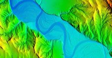
Woolpert has secured a contract with the University of Wyoming to generate a digital terrain model and contours. Leveraging Lidar data previously acquired for the United States Geological Survey (USGS),...

Global reference systems such as the International Terrestrial Reference Frame provide the foundation for determining positions on Earth and in space, as well as for reliably quantifying our planet’s changes...
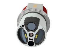
ClearSkies Geomatics, based in Colorado, USA, has recently added the RIEGL VQ-1560 II-S airborne laser scanner to its growing rental system fleet. This laser scanner, an advancement of RIEGL's dual-channel...

In a groundbreaking collaboration, Genesys International and Survey of India (SOI) have formed a strategic alliance to create digital twins of major cities and towns. This partnership is aimed at...

Calling all geospatial professionals! You’ve no doubt been involved in inspiring projects and applications that leverage innovative reality capture methods and advanced technologies. In the spirit of knowledge exchange, why...

Celebrating four decades as a pioneering force in the UK and Ireland's geospatial industry, Murphy Geospatial has unveiled its innovative mobile-mapping solution called GeoDrive. This groundbreaking technology enables the collection...
A global audience of geospatial professionals witnessed the presentation of the JOUAV VTOL Hangar, a groundbreaking development in the field of vertical take-off and landing (VTOL) drones, at Intergeo 2023....
This site uses cookies. By continuing to use this website, you agree to our Cookies Policy. Agree