Maptek Launches Spatial Data Application PointStudio
Maptek has launched a new point cloud processing and modelling software called PointStudio 8 – a new name, platform and ribbon interface evolving from I-Site Studio. The next generation 3D...
Maptek has launched a new point cloud processing and modelling software called PointStudio 8 – a new name, platform and ribbon interface evolving from I-Site Studio. The next generation 3D...

The deployment of SAR in the space sector market has witnessed a tremendous increase lately, particularly due to the challenges in monitoring climate change and other environmental factors. Environmental remote...

Bentley Systems, a global provider of comprehensive software solutions for advancing infrastructure, has announced the acquisition of Plaxis, a provider of geotechnical software, based in Delft, The Netherlands. Bentley has...

Bentley Systems, a leading global provider of comprehensive software solutions for advancing infrastructure, has announced the acquisition of Plaxis, the leading provider of geotechnical software, based in Delft, Netherlands, and...

IDS GeoRadar, a leading provider of Ground Penetrating Radar (GPR) and interferometric solutions, has launched HYDRA-X, a radar-based technology solution specifically designed to support geotechnical engineers in the mining industry....
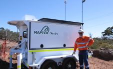
Maptek has announced it will be displaying its latest mobile monitoring system at Slope Stability 2018. “At its heart, the conference is tackling an issue, slope stability, which has a...

Maptek has launched its new I-Site SR3 600m range laser scanner, developed to become the mine measurement standard for underground operations, both for general underground survey and detailed geological face...
Maptek has unveiled its latest scanner, the SR3. With a 600m range, the R3 series is 30% smaller and 25% lighter, with 2.5 times faster data acquisition than the earlier...

What is the current status of surveying in the mining industry, and which types of survey equipment and technologies are being used today? Geospatial data forms the foundation of mining....

Fugro has won a second major contract from the Norwegian Public Roads Administration (NPRA) for the largest road project in Norway’s history. The work on the E39 Coastal Highway will...
This site uses cookies. By continuing to use this website, you agree to our Cookies Policy. Agree