Zebra Imaging
Atech Tecnologias Críticas of Brazil has acquired a CASI-1500 imaging sensor of ITRES, developed with RF-based remote operation capability. Also delivered is a Novatel SPAN GPS/IMU for the provision of...

Since the launch of the first Very High Resolution commercial satellite, European Space Imaging has been providing the best possible spatial resolution to the European market. From our inception in...

Airborne hyperspectral surveys are challenging. Complex measurement devices and cumbersome support equipment need to be installed aboard the aircraft, while the massive amounts of collected data require heavy post-processing to...

Planet was founded with the mission to image the Earth every day and make change visible, accessible, and actionable. Over the past decade with our customers, Planet has revolutionized the...

European Space Imaging has recently rebranded to the acronym of EUSI. The decision to modernize the company's brand was made to reflect its commitment to innovation and the reliability of...

A man who received a 360-degree camera as a gift has taken it upon himself to incorporate his neighbourhood in Guernsey into the Google Street View online map, according to...
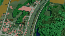
Innovative methodologies based on artificial intelligence (AI) are lowering the barriers and democratizing the use of 3D digital twins in the geospatial industry. Digital twins are revolutionizing the geospatial industry,...
Cyberhawk has entered into a global partner agreement with Phase One. Together, they will deliver the utmost standard of industrial inspections to the most discerning customers, leveraging the advanced capabilities...
This site uses cookies. By continuing to use this website, you agree to our Cookies Policy. Agree