Portable Laser Scanning System
3D Laser Mapping (UK) has developed a portable laser scanning system for mapping overhead infrastructure such as power lines. With adverse weather and over-grown vegetation increasingly causing damage to overhead...
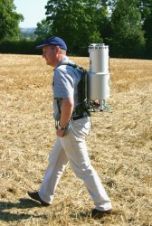
3D Laser Mapping (UK) has developed a portable laser scanning system for mapping overhead infrastructure such as power lines. With adverse weather and over-grown vegetation increasingly causing damage to overhead...

RIEGL has announced the launch of two innovative topobathymetric scanners. These advancements mark a shift towards enhanced efficiency and precision in data collection across land and water interfaces. The RIEGL...
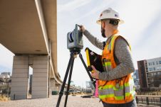
Trimble has recently announced the Trimble X9 3D laser scanning system, a versatile reality capture solution for surveying, construction and engineering professionals. The X9 is built on Trimble's proven laser...

The demand for 3D maps of cities and road networks is steadily increasing and mobile mapping systems are often the preferred acquisition method for capturing such scenes. Manual processing of...

The demand for 3D maps of cities and road networks is steadily increasing and mobile mapping systems are often the preferred geodata acquisition method for capturing such scenes. Manual processing...

As the world's population keeps growing and changes in buildings and infrastructures become more rapid, there is an increasing need to document this growth and these changes. A revolutionary approach to...
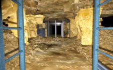
Laser scanning technology has been used to create a permanent and lasting record of post-mediaeval underground mines under the city of Bath, UK. The project by Oxford Archaeology employed laser...
High measurement rates and centimetre precision point-clouds are state-of-the-art in mobile laser scanning. The introduction of photogrammetric features as next logical step considerably expanded the horizon of potential applications. Digital...
Optech is to organise its fifth International Terrestrial Laser Scanning User Meeting on 8th and 9th June 2010 in Prague, Czech Republic. Optech clients and expert users of static and...
Last month we reported back from the Intergeo trade show that it was all about three abbreviations: Airborne Laser Scanning (ALS), Terrestrial Laser Scanning (TLS) and Mobile Laser Scanning (MLS)....
This site uses cookies. By continuing to use this website, you agree to our Cookies Policy. Agree