Trimble Mobile Mapping Solutions
Take control of the way you work. Scanning, imaging, processing, and sharing at speed and scale. Trimble Mobile Mapping technology unlocks the next generation of geospatial projects. Learn More→

Take control of the way you work. Scanning, imaging, processing, and sharing at speed and scale. Trimble Mobile Mapping technology unlocks the next generation of geospatial projects. Learn More→
JOUAV has released the JoLiDAR-1000 Lidar sensor designed specifically for uncrewed aerial vehicles (UAVs or ‘drones’) as the latest addition to its array of high-performance Lidar sensors for use in...

Sven Cowan is NV5 Geospatial’s Programme Manager for Canada. He has over 20 years of experience in customer-facing positions within the geospatial information industry and has worked for multiple geospatial...

Visitor registration is now open for GEO Business, the UK's largest geospatial event. The free-to-attend expo, tailored for geospatial professionals seeking to harness the potential of location intelligence, will return...
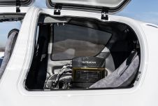
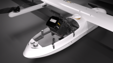
Diamond Aircraft and Vexcel Imaging have announced the next collaboration for a further expansion of Diamond’s special mission aircraft high-end sensor portfolio. The partnership will integrate the UltraCam Dragon 4.1...

A topobathymetric Lidar survey was conducted to support flood preparedness in Canada. Which techniques achieved exceptional precision, and what were the logistical challenges? Find out more in this article. As...

Leica Geosystems mobile mapping day featured the UK release of two new pieces of equipment and a refresh of two others. The day at Milton Keynes was a mix of...
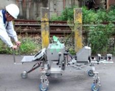
Common mobile mapping systems heavily rely on positioning using GNSS. However, concrete, soil and other materials block GNSS signals, thus impeding their use when inspecting pipelines, subways or other underground...

Trimble's Indoor Mobile Mapping System (TIMMS) is a manually operated push-cart designed to accurately model interior spaces without accessing GPS. It consists of 3 core elements: Lidar and camera systems...
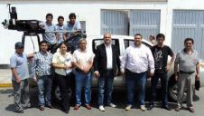
Topcon Positioning Systems (TPS) Latin American distributor Geomatic Instruments Corporation (Geincor, Peru) is now offering the IP-S2 mobile mapping system. Geincor took ownership of the system in April 2011. ...
This site uses cookies. By continuing to use this website, you agree to our Cookies Policy. Agree