Aubrey Miller
Aubrey Miller is a senior professional practice fellow at the School of Surveying, University of Otago, and member of the Mountain Research Centre in Aotearoa, New Zealand. He teaches and...

Aubrey Miller is a senior professional practice fellow at the School of Surveying, University of Otago, and member of the Mountain Research Centre in Aotearoa, New Zealand. He teaches and...
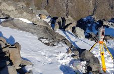
A project in Aotearoa/New Zealand is combining the use of high-quality DEMs from satellite photogrammetric mapping (SPM) with Lidar technologies to model hazards such as snow avalanches. The resulting topographic...
Preparations for Intergeo 2022, the world’s leading conference and trade fair for the geodesy, geoinformation and land management community, are in full swing. This year’s event, featuring three full days...
“Think big for coastal mapping” is the foremost advice that Don Ventura of Teledyne Geospatial would impress upon agencies interested in bathymetric Lidar. “It’s a matter of efficiency of scale.”...

The Open Geospatial Consortium (OGC) seeks public comment on version 1.3 of the OGC Indexed 3D Scene Layer (I3S) and Scene Layer Package Format Community Standard. Version 1.3 adds support...

When it comes to utilizing the true potential of digital twin technology, Singapore is miles ahead of most other governments. Even those that have already embraced the concept of the...
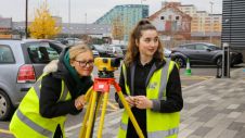
So you'd like to do something in 'geospatial' – but what? New graduates in geomatics and surveying are extremely sought-after in the labour market thanks to their broad scientific background,...

Attendees of YellowScan's recent Lidar for Drone 2022 Conference headed home with a backpack full of inspiration, according to Wim van Wegen. A relaxed vibe, sunny weather with summer temperatures,...

Pix4D will be hosting its flagship conference in Denver, Colorado, on 13 October 2022. The event includes expert guest speakers on 3D modelling and photogrammetry, personal consultations, networking opportunities, the...
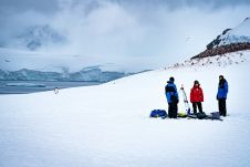
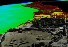
Capturing and measuring the environment in the Arctic and Antarctic is a particularly challenging job. The area of interest is often covered by a thick blanket of snow and ice,...
This site uses cookies. By continuing to use this website, you agree to our Cookies Policy. Agree