OGC Supports European Data Modelling Workshop
The Open Geospatial Consortium will join EUROSDR, AGILE, JRC and ELF in presenting an important technical workshop focused on the geospatial elements of data models. The workshop will be held...

The Open Geospatial Consortium will join EUROSDR, AGILE, JRC and ELF in presenting an important technical workshop focused on the geospatial elements of data models. The workshop will be held...

European Association of Aerial Surveying Industries Planning, disaster management, and safety challenges inherent in complex urban environments call for innovative solutions. Researchers around the world are progressing the field, drawing upon cutting-edge work using approaches such...

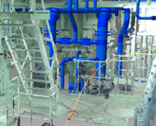
The 90-year-old Shukhov Tower in Moscow, Russia, is not only in a state of severe disrepair but the 150m-high steel construction is also under-documented. To support restoration initiatives or, in...
Elysium, an emerging Japan-based provider in the point cloud data industry, has released a new version of InfiPoints. Version 2.0 highlights enhancements such as pipe modelling and video generation from...

One of the UK’s leading survey firms has produced a client ready specification for BIM surveys and deliverables. Richard Groom runs his eye over the content. Who better to write...
UK-based environmental engineering company Cambridge Environmental Research Consultants (CERC) has been using the TatukGIS Developer Kernel (DK) ActiveX edition since 2007 to develop the GIS mapping module for its ADMS...

Last month, Envitia, UK, announced the launch of Envitia Discovery 2.7 for modelling and simulation. Envitia Discovery allows organisations to seamlessly share and reuse geospatial and modelling data. Users are...
The Open Geospatial Consortium (OGC, USA) and the United States Geospatial Intelligence Foundation (USGIF) Modelling and Simulation (M&S) Working Group will provide a demonstration of new standards developments that provide...
Russia has the intention to develop and implement a 3D cadastre. A Russian-Dutch project on 3D cadastre modelling assessed the added value of a 3D cadastre. At present, the system...
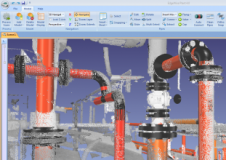
ClearEdge3D, USA, has officially launched EdgeWise Plant 4.0, with numerous major new features and enhancements that have created one of the fastest end-to-end pipe modelling solutions on the market. The...
This site uses cookies. By continuing to use this website, you agree to our Cookies Policy. Agree